SUMMARY
This is AI generated summarization, which may have errors. For context, always refer to the full article.
MANILA, Philippines – How can an archipelago like the Philippines with thousands of coastal communities mitigate the effects of storm surges caused by extreme weather conditions?
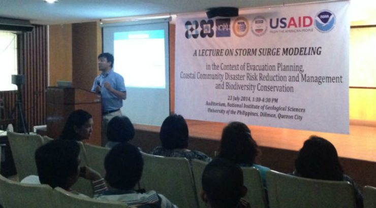
On Wednesday, July 23, representatives of national agencies and the academe gathered at the University of the Philippines National Institute of Geological Services (UP NIGS) to discuss storm surge modelling for evacuation and disaster risk reduction and management (DRRM) in coastal communities.
According to Dr Flaviana Hilario, acting deputy administrator of state weather bureau PAGASA, storm surge became a buzzword for Filipinos because of Super Typhoon Yolanda (Haiyan).
“After Yolanda, the whole country now knows what storm surges are. This experience taught us that we really need to enhance our forecast ability for storm surges,” Hilario said.
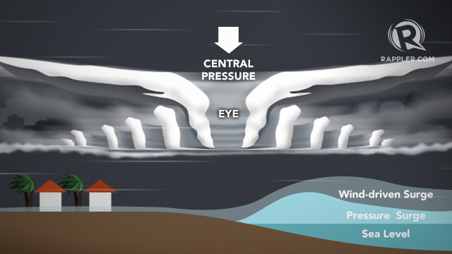
A storm surge happens when the sea level rises beyond the normal tide levels, due to strong winds and low pressure from typhoons.
Yolanda, known as the strongest typhoon to hit land, pounded Eastern Visayas with strong winds and storm surges. It inundated many coastal communities in Leyte and Samar provinces.
In Tacloban City alone, waves of 5 to 6 meters high destroyed millions worth of property and claimed thousands of lives.
‘Not a new experience’
But Hilario said storm surge is not new to the country. The Philippines has been hit by such phenomenon for the past hundred years. (READ: Storm Surge 101: Are you at risk? Are you prepared for it?)
“We have a long history of storm surges in the Philippines, given that we have 20 tropical cyclones a year. We have maps of where storm surges hit from 1870s to 1911,” Hilario said.
Dr Mahar Lagmay, Project NOAH director, said the most recent occurence of storm surges before Yolanda happened during the habagat in 2011.
According to Lagmay, Manila was ravaged by 2-meter high waves that reached Taft Avenue. Some establishments along Roxas Boulevard were destroyed.
Lagmay said, however, that Filipinos tend to forget easily. Instead of remembering the devastation caused by the storm surge, the incident was more known for the memes that spread because of it.
“That would have been a good example of the devastation that can be brought by storm surges. We easily forget. We tend to blame others but we don’t look at our own faults,” he added.
The US experience and model
To help the Philippines develop better storm surge modelling, Dr Keqi Zhang of the United States National Oceanic and Atmospheric Administration (NOAA) shared the system they use to track storm surges brought by hurricanes.
The Sea, Lake, and Overland Surge from Hurricanes (SLOSH) is a system that generates storm surge inundation (how far the water will reach land) maps and forecast for the US Atlantic coast and other Caribbean countries. It has a 20% uncertainty in the model result (margin of error) and is used to determine which coastal areas can be used for residential purposes or basins.
Some of the inputs for SLOSH are the central pressure of a cyclone, storm size, storm track and maximum sustained winds. Physical features like topography, body of water orientation and depth of sea bottom are also taken into account.
According to Zhang, tracking hurricanes and other extreme weather conditions are always challenging.
“When a hurricane approaches, we will know which direction it will go. But where it will make landfall can always change. This is why we create 3 outputs,” he added.
SLOSH creates 3 storm surge outputs. These are the following:
- Maximum Envelope of Water (MEOW) – This provides a worst case snapshot of the basin for a particular storm category, speed, and trajectory. “It’s very hard to know in advance whether the storm surge will coincide with high tide and low tide. So we simulate the surge in 2 cases – high and low tide,” Zhang said. MEOW is used for mitigation and planning purposes.
- Maximum of Maximums (MOMs) – This allows for cyclone track or forecast uncertainties. NOAA runs several models with worst-case water heights and other factors. “We calculate the possible direction and the maximum of possible water level. We calculate all the possible landfalls and direction of the hurricanes,” Zhang said. MOMs are used for preparing for hurricanes, some 48 to 120 hours before landfall.
- P-surge Cross-Track error – This uses statistics from past typhoons to include 90% of possible cross track error. “Once you get the storm surge probability, it provides ensemble of hypothetical storm runs and associated weighs.” This is used if a storm changes path less than 48 hours before landfall.
Is SLOSH applicable to the Philippines?
Zhang admitted that SLOSH might need major tweaks for it to work in the Philippines.
“The US coastline is relatively straight. We haven’t tried it for archipelagos like the Philippines. This is the first time we’re testing it in an international scale,” he added.
He also raised the need to communicate studies like this better to the public and decision makers.
“Physical science alone will not holistically address storm surge challenges. Clear and consistent information is critical. We need consistent definitions and frames of references,” Zhang said.
Learning from Yolanda

When Yolanda struck, Filipinos accused Pagasa and other government agencies of not explaining and communicating well enough the dangers of storm surges.
Lagmay admitted that more could have been done to explain the hazards.
“We lacked visual communication for the people during Yolanda. We need more videos because videos communicate better with people,” he said.
Lagmay said that there are 2 crucial factors in mapping hazards – (1) creating warnings; and (2) communicating such warnings for the appropriate response.
He added: “The warning was there but the appropriate action was not. Some 80% of Tacloban residents were evacuated to centers that were also in harm’s way.
Lagmay cited the need for local mapping so storm surge models can create more accurate information.
“Maps are very important. Even if you understood what storm surges are, you wouldn’t know how far the water will go in land. We need a map to refer to,” Lagmay concluded.
The forum was held in partnership with the US Agency for International Development (USAID), the Department of Science and Technology (DOST), PAGASA, and NOAA. – Rappler.com
CORRECTION: In an earlier version of this report, we said that SLOSH is 20% accurate. SLOSH actually has a 20% uncertainty in the model result or margin of error.
Add a comment
How does this make you feel?


There are no comments yet. Add your comment to start the conversation.