SUMMARY
This is AI generated summarization, which may have errors. For context, always refer to the full article.
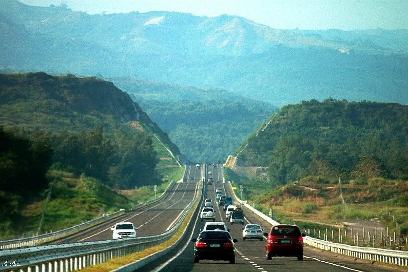
MANILA, Philippines — It’s vacation time again! Are you going home to the province or going on a road trip?
Of the 216,016 kilometers of roads nationwide, how much have you seen? What are your favorite spots along Philippine roads?
Here are some quick facts about the roads that many of you probably pass through everyday:
1. Pan-Philippine Highway
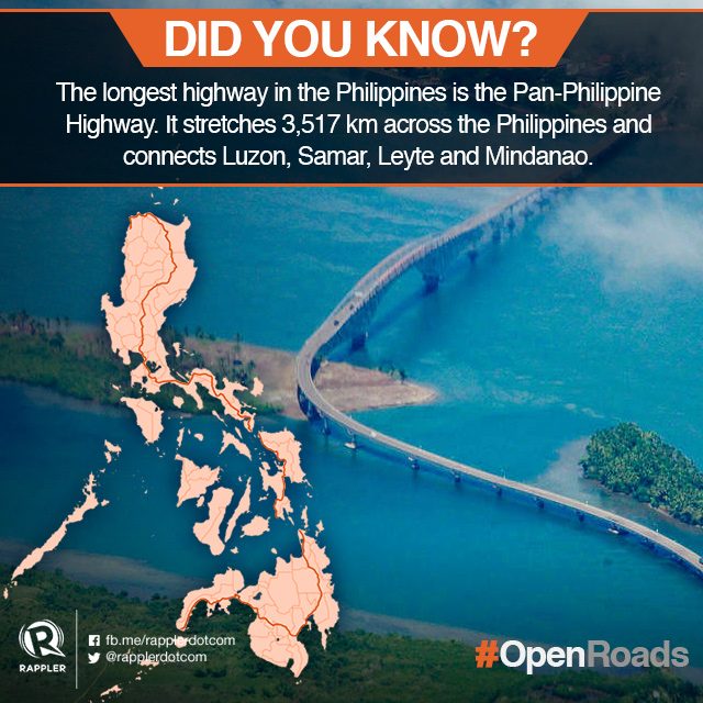
Pan-Philippine Highway, also known as “Daang Maharlika”, is the longest highway in the Philippines. Labelled as N1 in the Route Numbering System of the Department of Public Works and Highways (DPWH), it stretches 3,517 kilometers from Laoag City, Ilocos Norte to Zamboanga City and passes by the Patapat Viaduct in Pagudpud, Ilocos Norte and other scenic spots.
It was first conceptualized in 1965 during the administration of Ferdinand Marcos. In 1997, the highway was further improved with assistance from the Japanese government.
Roll-on/roll-off (RORO) ferry routes close the sea gap between Matnog, Sorsogon and Allen, Northern Samar; and between Liloan, Southern Leyte and Surigao City, Surigao del Norte. Islands of Samar and Leyte are connected by the San Juanico bridge.
The Maharlika Highway is also part of the Asian Highway Network, a project of Asian Land Transportation Infrastructure Development (ALTID) of the United Nations Economic and Social Commission for Asia and the Pacific (UNESCAP). Within this regional road network, the route number given to this highway is AH26. (READ: AH26: What does this road sign mean?)
2. Halsema Highway
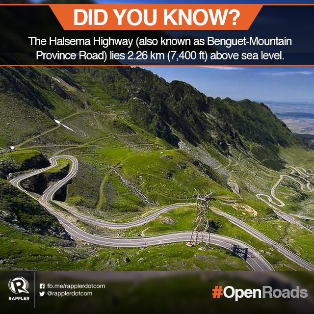
Halsema Highway, also known as Benguet-Mountain Province Road, is the country’s highest road constructed above sea level. Its highest point, 2.26 km (7,400 ft) above sea level, is situated in the municipality of Atok, Benguet.
Initially built as a foot trail in the 1920s, Halsema Highway is now a major highway in Northern Luzon. The 150-km road connects Baguio City to the municipality of Bontoc, Mountain Province.
While parts of the winding highway are especially dangerous during the rainy season as roads become slippery and landslides are common, a drive along Halsema offers cold, breezy mountain air and breathtaking views.
What you shouldn’t miss on this road: the view of Mt. Pulag, a glimpse of Ambuklao Dam and clouds rolling over the mountain range.
3. Subic-Clark-Tarlac Expressway
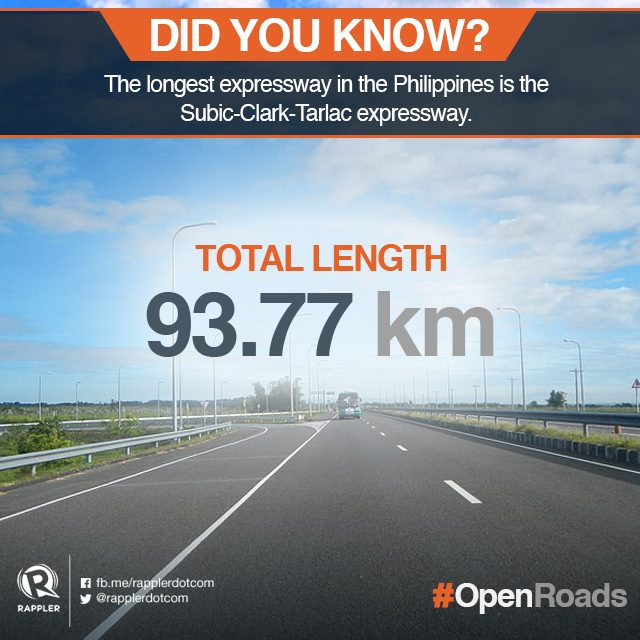
Region III’s Subic-Clark-Tarlac Expressway is the country’s longest expressway.
Passing by breathtaking view of fields and majestic mountain ranges, the 93.77-kilometer road extends from the Subic Bay Freeport Zone to Tarlac City and passes through the heart of Hacienda Luisita.
Built from 2005-2008, the SCTEX has since made tourist destinations in Central and Northern Luzon more accessible. Travel time to Zambales’, Bataan’s and Olongapo’s pristine beaches, Mt. Pinatubo trek via Capas, Tarlac, the Hundred Islands in Pangasinan and La Union’s Thunderbird Resorts Poro Point are now almost cut into half.
4. Commonwealth Avenue
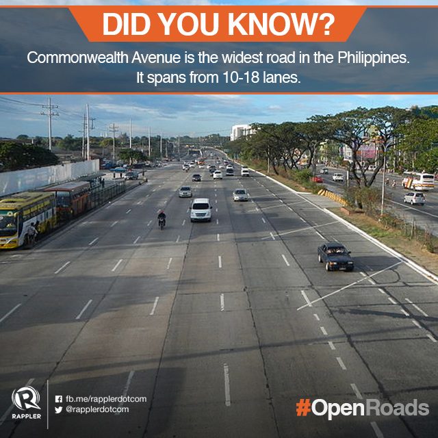
Spanning 10-18 lanes, Commonwealth Avenue is the widest road in the Philippines. It is also known as the “killer highway” due to the frequent accidents in the area.
First constructed in the 1960s, it starts from the Quezon Memorial Circle inside the Elliptical Road and ends at the Quirino Highway in Novaliches. The avenue is divided into two portions: the 6-8 lane Fairview Avenue and the 18-lane Don Mariano Marcos Avenue.
Along the Commonwealth Avenue, government establishments like the Sandiganbayan, Commission on Audit and the Philippine Coconut Authority will be found.
5. Colon Street
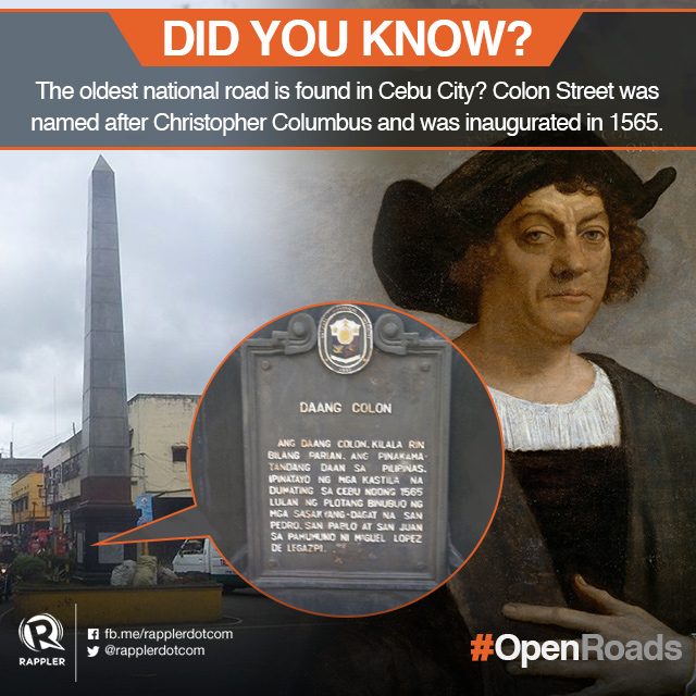
Cebu’s Colon Street is the country’s oldest national road. It was inaugurated in 1565 and was named after the Italian navigator Christopher Columbus (Cristóbal Colón in Spanish).
Located in downtown Cebu City, Colon Street is one of the most crowded streets in the city. The whole stretch is filled with shops, stalls, sidewalk vendors and passenger jeepneys — comparable to Manila’s Divisoria.
Tell us more about roads you like! Did we miss any spots that are worthy of pride? Let us know what you think by tagging us and tweeting #OpenRoads!
Are you on a road trip? Tweet with your precise location on and your tweets will get automatically mapped on agos.rappler.com/open-roads. —Rappler.com
What roads need to be properly maintained or built in order to promote development in poor communities within the country? Let us know. Take photos, turn on precise location and tweet using #OpenRoads!
Learn more about how you can help improve road conditions in the Philippines:
- #OpenRoads: Adopt roads that matter to you
- Rappler Talk: What roads matter to you?
- #TheLeaderIWant: Cebu youth identify roads that matter to them
- #OpenRoads: Share photos of roads that matter to you
- How open data help build better roads, communities
The #OpenRoads campaign is done in partnership with the World Bank Group.
Add a comment
How does this make you feel?
There are no comments yet. Add your comment to start the conversation.