SUMMARY
This is AI generated summarization, which may have errors. For context, always refer to the full article.
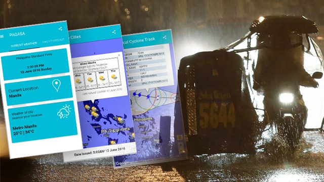
MANILA, Philippines – State weather bureau Philippines Atmospheric Geophysical and Astronomical Services Administration (PAGASA) launched an upgraded version of its smartphone application called “DOST PAGASA” on Monday, June 13.
Download DOST PAGASA Mobile App “Tracking the sky… Helping the country”https://t.co/8lPaGty1Ec pic.twitter.com/UnNWHDi23P
— PAGASA-DOST (@dost_pagasa) June 14, 2016
The app provides users key information on weather, flooding, and hazard which can help them during times of disasters and typhoons. The app specifies the weather forecasts it gives by narrowing down the information depending on the user’s location.
Eight of the 10 most disaster-prone cities in the world are in the Philippines, according to a 2015 research conducted by risk analysis firm Verisk Maplecroft said. While natural hazards like flooding can’t be avoided, the public can help minimize their adverse effects through disaster preparedness – an idea the app aims to reinforce.
The app, which can now be downloaded by Android users, makes use of satellite and radar images to map users in order to give vital information. These useful information are also shareable through various social media platforms such as Facebook and Twitter.
The development is part of the program between Japan International Cooperation Agency and PAGASA called “JICA, Philippines and PAGASA on Weather” (J-POW) that is geared towards enhancing the Philippines’ capacity on weather observation, forecasting, and warning.
Highlight
Gathering 4.5 out of 5 stars on Google Play, the app received praise from users who claimed that the app is “very informative” and gives accurate information.
App user Marc Anthony Reyman, who gave the app 5 stars, commented, “All the information we need for the PH weather in a mobile app. I like the maps very informative specially the typhoon path.”
Users also gave thumbs up to the typhoon-mapping feature of the app, which allows users to track the path taken by weather disturbances on actual map. Reyman added that the feature allowed them to path the typhoon in a map “we can navigate.”
The app can measure the distance of the user from the typhoon by using global positioning system (GPS).
JICA lauded the weather bureau for the technological innovation and cited that the mobile app will help in disaster preparedness.
Yumi Shultz, JICA project coordinator, commended the project for addressing the information dissemination woes on meteorological information.
Technology and disasters
“JICA will continue to partner with PAGASA in raising disaster awareness in the Philippines by giving opportunities to ordinary Filipinos to have easy access to warnings and up-to-date weather bulletins,” Yumi said.
The J-POW program also helped in disaster preparedness campaigns in Southern Luzon, where both agencies conducted seminars and information drive on typhoons, storm signals, and storm surges.
The Japanese development institution also has over 20 disaster risk reduction programs currently running in different areas in the country.
Philippines is not a stranger to typhoons. The nation of 100 million people is battered by an average of 20 typhoons every year.
Groups have been innovating to improve the country’s disaster risk reduction management. Rappler’s Agos, for example, uses mobile and web technologies and social media, to ensure the flow of critical and actionable information to those who need it before, during, and after disasters. – Rappler.com
A student of the University of the Philippines Visayas, Adrian Jimenea is a Rappler intern.
Add a comment
How does this make you feel?
There are no comments yet. Add your comment to start the conversation.