SUMMARY
This is AI generated summarization, which may have errors. For context, always refer to the full article.
LEYTE, Philippines — Every year, more than 20 typhoons visit the country, making our communities susceptible to hazards like flooding. Beyond the damage this poses to the country’s agricultural resources, it also makes lives at risk due to these hazards.
With this challenge in mind, a research team from the Visayas State University (VSU) in Baybay City, Leyte produced hazard and resource maps for about 40 municipalities and cities from the provinces of Leyte, Southern Leyte, Samar, Eastern Samar, and Northern Samar.
The Philippine Light Detection and Ranging (Phil-LiDAR) research project started in 2014, initiated by the University of the Philippines Diliman’s Disaster Risk and Exposure Assessment for Mitigation (DREAM) Program.
The program, funded by the Department of Science and Technology (DOST), rolled out nationwide by partnering with higher education institutions in different regions as partners.
VSU led the implementation for Eastern Visayas.
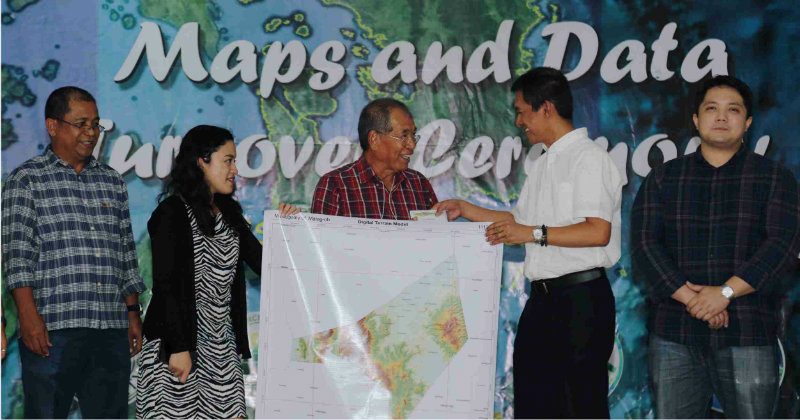
On May 26, VSU Phil-LiDAR 1 and 2 projects turned over high resolution maps, and data in CDs to representatives of local government units in the 5 provinces of Region 8 after 3 years of research.
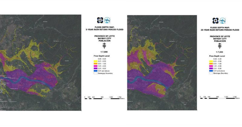
The flood hazard maps, produced by Phil-LiDAR 1, contain information on predicted flood depth and risk levels in areas close to river basins. On the other hand, the resource maps, produced by Phil-LiDAR 2, reflect the agricultural, forestry, coastal resources of a municipality or city, as well as potential renewable energy sources, and hydrologic data.
“The project both acquired aerial and elevation topography, and ground surveys to produce digital elevation models and come up with the flood hazard maps,” said UP Diliman Phil-LiDAR 1 Chief Science Research Specialist Christopher Uichanco.
Uichanco said he is hopeful that VSU’s outputs can help local government units (LGUs) create comprehensive flood advisory systems and design mitigation measures based on the data from the provided maps.
VSU Phil-LiDAR 2 project leader Dr Pastor Garcia said the maps can be used in planning disaster response and mitigation strategies as well as in developing agribusiness opportunities with the available untapped resources.
According to Garcia, the development of the maps partly serves as a response to NEDA’s call to provide regions with tools for decision-making.
Dr Ciriago Agner, Jr., the Chairman of the Committee on Environment and disaster risk management focal person in the municipality of Palo, expressed his gratitude to the Phil-LiDAR program.
“These maps from VSU Phil-LiDAR program will be a great help in reducing the vulnerability of our crops and other resources,” Agner said, recognizing the usability of the maps from their existing hazard maps.
Uichangco also demonstrated the Automated Water Level Forecasting System which can be accessed from the website. The system gives past and actual water levels of river basins as well as predicted risk levels.
The VSU Phil-LiDAR projects officially ended on May 31.
VSU President Dr Edgardo Tulin said the university will continue to provide technical services, and develop more technologies for disaster risk mitigation and economic growth as its responsibility to its neighboring communities. – Rappler.com
Aliana Gene Sarmiento writes development stories for Visayas State University.
This story was originally published at Visayas State University: http://www.vsu.edu.ph/rde-news/1260-phil-lidar
Add a comment
How does this make you feel?
There are no comments yet. Add your comment to start the conversation.