SUMMARY
This is AI generated summarization, which may have errors. For context, always refer to the full article.
MANILA, Philippines – Of the known active volcanoes in the Philippines, Mount Mayon is the most active, having erupted 48 times since its first recorded eruption in 1616.
The worst eruption of Mayon Volcano happened over 200 years ago, on February 1, 1814. It killed 1,200 people and partly destroyed the Cagsawa church. (READ: Looking back: Mayon Volcano’s most destructive eruption)
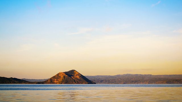
The second most active volcano is Taal Volcano in Batangas province with 33 recorded eruptions. Taal has the distinction of being closest to the country’s capital region, Metro Manila, among the active volcanoes.
After Taal, the next most active volcano is Mount Kanlaon in Negros island with 26 recorded eruptions.
In all, the Philippine Institute of Volcanology and Seismology (Phivolcs) is monitoring 23 active volcanoes.
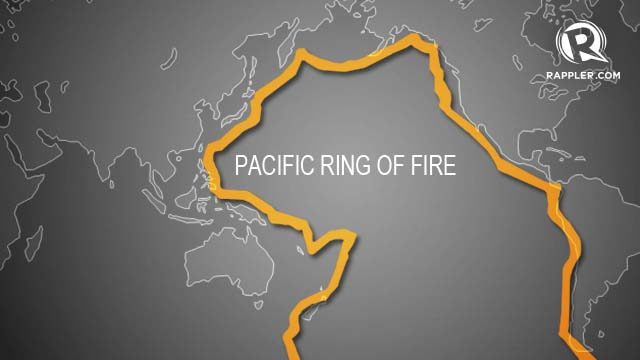
But Phivolcs Director Renato Solidum says this number could still increase given the country’s location within the Pacific Ocean’s Ring of Fire, a 40,000-circle of interconnected fault lines around the Pacific Ocean, where other seismic activities such as earthquakes also occur on a daily basis.
When is a volcano considered active?
“A volcano is considered active if it has erupted within the last 10,000 years (meaning there was a witness) or if it has a radiometric date of its deposit which is less than 10,000 years,” Solidum explained.
Mt Pinatubo, for instance, had no written record of eruption prior to 1991. It was considered an active volcano since 1987 mainly because of the Carbon 14 date showing it last erupted around 600 years ago.
When Phivolcs raised an alert warning for a possible eruption of Mt Pinatubo in April 1991, there were some who did not believe it because of the “lack of experienced eruption,” Solidum said.
Active volcanoes, no matter how many years they “rest” are still capable of devastating eruptions.
“If a volcano is classified as active, people should be prepared for a possible activity even if the volcano has not erupted in their lifetime,” Solidum explained.
Hard to predict
The Phivolcs’ mandate is to mitigate disasters that may arise from volcanic eruptions, earthquakes, tsunamis and other related geotectonic phenomena. Oftentimes, however, such activities are hard to predict.

In 2013, 5 people – 4 German tourists and their Filipino guide – were killed when Mayon Volcano suddenly spewed rocks and steam in a phreatic explosion, which is hard to predict, according to Solidum.
The incident happened within the area that local authorities, with advice from Phivolcs, has designated as the Permanent Danger Zone (PDZ). Sudden gas-driven explosions may take place anytime within this area, which is within the 6-kilometer radius around the volcano.
“Ideally, there should be no permanent settlement allowed. Entry inside PDZ allowed if [a volcano is] at Alert Level 0, but climbers to summit [are] at risk to steam driven explosion and should take precaution,” Solidum explained.
So far, there are 4 other active volcanoes in the Philippines with PDZs: Taal (whole island), Kanlaon and Bulusan (4 km) and Hibok-Hibok (3 km). These volcanoes frequently erupt, Solidum said.
He added that those living near a volcano should be updated about its condition based on Phivolcs monitoring. They should also observe “natural signs of renewed activity.” More importantly, they should be aware of the areas that need to be evacuated and the location of evacuation centers, should a volcano start showing signs of unrest.
Here is a map of active volcanoes in the Philippines with some hazard maps released by Phivolcs.
– Rappler.com
Sources: Philippine Institute of Volcanology and Seismology, www.volcanodiscovery.com, www.volcanolive.com, various news websites
Photos from Phivolcs and WikiCommons
Taal Volcano image via Shutterstock
The Philippine Institute of Volcanology and Seismology (Phivolcs) is a partner of Rappler in Project Agos, a collaborative platform that combines top-down government action with bottom-up civic engagement to help communities learn about climate change adaptation and disaster risk reduction. Project Agos harnesses technology and social media to ensure critical information flows to those who need it before, during, and after a disaster.
Project Agos is supported by the Australian Government.
Add a comment
How does this make you feel?
There are no comments yet. Add your comment to start the conversation.