SUMMARY
This is AI generated summarization, which may have errors. For context, always refer to the full article.

MANILA, Philippines – One day in September, a group of Taclobanons and environmentalists foresaw that a super typhoon named Hagibis would wreak havoc in their city in year 2020.
The prediction was for a scenario-building exercise with Worldwide Fund for Nature (WWF) Philippines to help the city assess its disaster-preparedness.
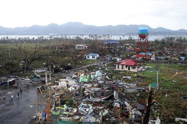
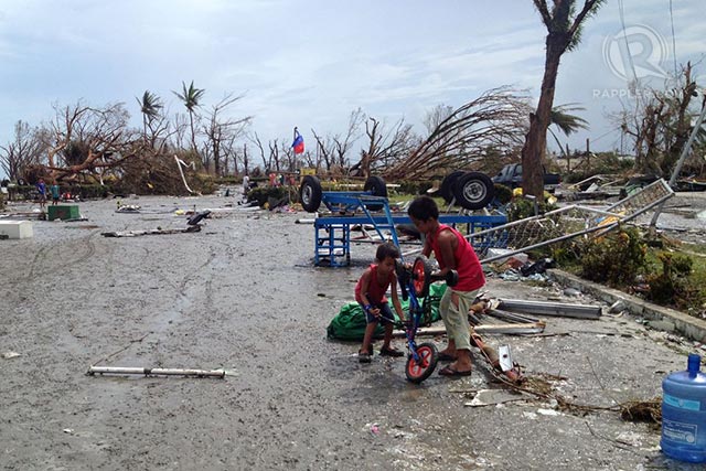
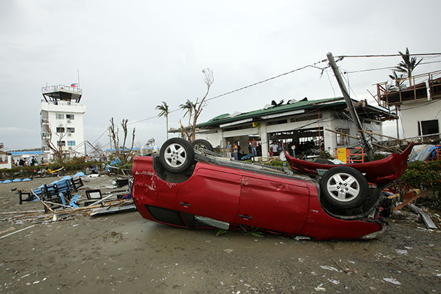
Today, Tacloban is a wasteland where dead bodies rot in open air and survivors struggle to live. Almost all homes and structures are obliterated. Food and water are in scarce supply. Taclobanons never expected the storm to come 7 years early. (READ: Tacloban devastated; at least 100 dead)
There are many reasons why Tacloban was among the cities worst-hit by nightmare-turned-reality Super Typhoon Yolanda (Haiyan). Some of these reasons were predicted by the study that resulted from the scenario-building exercises in Tacloban.
The city’s large population, high level of urbanization, location and weak coastal areas all contributed to Tacloban’s unique vulnerability, revealed the study.
Entitled “Business Risk Assessment and the Management of Climate Impacts,” the study evaluates the vulnerabilities of select Philippine cities to the impacts of climate change which includes extreme weather events like storms.
Tacloban is one of 12 cities assessed by WWF-Philippines and other experts from 2011 to 2013. Initially due for release in December, the launch of the Tacloban assessment was moved to end of December to include an analysis of Yolanda.
The document aims to help local government leaders, city planners and the business sector create strategies to ensure the city’s survival and strengthen its economy in the face of disaster.

Monci Hinay, who led the Tacloban assessment team, said the study assessed the city on 3 main variables: its climate or environmental exposure, social economic senstivity, and adaptive capacity.
Climate or environmental exposure considers climate, temperature, and rainfall.
Social economic sensitivity looks at demographics, tourism, export, water, energy, land values, agriculture and fisheries.
Adaptive capacity is measured by crime solution efficiency, local government performance, family savings and city savings.
“It’s a year-long project where we look at 20 years of data and use it to forecast 30- to 50-year scenarios. Then we added inputs from local stakeholders through the scenario-building exercise,” he explained.
The local stakeholders were composed of local government officials, the private sector, academe and non-government organizations.
1. Location
Geohazard maps of Tacloban already showed how exposed the city was to danger.
“If you look at the geohazard map of Tacloban, only a small part is not red. Red meaning highly vulnerable to climate change impacts. The LGU saw that already,” said Hinay.
Tacloban is bound on the east and south by water leading to Leyte Gulf and the Pacific Ocean. In the north and the west, it is bound by mountains. Thus, the city was trapped. In the face of the 15-foot-high storm surge that submerged its coastal communities, Taclobanons could not evacuate further than the mountains.
The same wall blocking their path is a danger spot in itself. Mountains often mean landslides, especially when the winds and rain were as strong as Yolanda’s.
2. Land subsidence
Further making Tacloban vulnerable to flooding caused by storm surge is the fact that much of it is below sea level, said Hinay. In many places, there were also cases of land subsidence in which “sea water enters the soil, slowly eating away the coastal areas,” explained Hinay.
Land subsidence also happens when humans draw water from the soil for drinking, bathing and other uses. The extraction of water creates spaces between soil particles. When the roof over these spaces cannot support all the intact soil above it, it collapses thereby lowering the level of soil on the surface.
Subsidence lowers the land surface a couple of centimeters every year. The lower the land goes, the more likely it will be inundated when sea levels rise or flooding occurs. Eventually, the land will become so low that flooding will happen even during high tide.
3. Population, urbanization
Tacloban is Eastern Visayas’ migratory city, said Hinay.
“Vast lands and good weather create a migratory sink. If you have really good weather and plenty of lands, people will go to your land regardless of the situation. For example in Zamboanga, even if peace and order is bad, they still go.”
Tacloban is home to around 200,000 people. A bigger population often equates to more urbanization as more people require more housing, livelihood opportunities, infrastructure and facilities. But it also means more risk.
“It causes concentrated risk. The more people will go to an area, the denser an area is, the more vulnerable to the effects of typhoons,” he said.

High population may also mean the pace of urbanization was harder to manage and control. Despite land subsidence and the fact that Tacloban’s coastal areas are below sea level, many important buildings were built right by the sea including the city hall, elementary schools, colleges and hospitals.
These could have been used as evacuation centers but because they too were close to the shore, they were among the structures first inundated by the storm surge.
But international disaster experts agree that not even the best prepared countries would have been spared by Yolanda, a storm that literally went off the charts. (READ: Conversations with disaster experts)
“Given the destructive nature with which Haiyan hit the central Philippines even the best-prepared nation would have a hard time bracing itself against the effects of such a storm,” Kathryn Hawley, a disaster management expert from Asia Foundation told Rappler’s Marites Vitug.
“When we try to prepare for hazard impacts as disaster managers we look to worse case scenarios but hope they never happen… When they do there are so many variables that can crumble the best-laid plans or preparation.”
Recommendations
After survival, the focus will be on reconstruction. Hinay said the study also makes recommendations on how Tacloban can better adapt itself to more extreme weather events in the coming years.
One such recommendation is moving development to higher ground.
“Relocate higher. If they want to create coastal redevelopment, they should factor in 3 to 4-meter-high (9.8 to 13 feet) storm surges. Tacloban is one meter below sea level so you have to create coastal redevelopment that is higher than the storm surge,” he explained.
He also urged the city to redefine land use based on Yolanda’s devastation. Where should residences, schools, hospitals, businesses now be located?
Investing in other sources of energy may also be a good idea, he said. Tacloban’s dependence on the power grid left it in the dark when Yolanda destroyed all power lines. Investing in renewable energy may help lessen this potentially fatal dependence.
“If you want your city to be more sustainable, you need renewable energy. It’s more competitive, more sustainable. If you get cut off from the grid, at least the community can use renewable energy. We’re also looking at resiliency of businesses and government. If there’s a brown-out, they can still function and provide much-needed services if they have an alternative source of energy.”
Renewable energy sources like solar panels do not need electricity to function. If they are stored in a high area in the city, safe from flooding and storm surges, it can be used to power the community using only energy from the sun.
The complete assessment study will be released end of December, along with assessments of cities Angeles, Batangas and Naga.
WWF-Philippines also made climate change assessments of Baguio, Cagayan de Oro, Cebu, Davao, Dagupan, Iloilo, Laoag and Zamboanga from 2011 to 2012. The studies can be viewed here. – Rappler.com
Add a comment
How does this make you feel?
There are no comments yet. Add your comment to start the conversation.