SUMMARY
This is AI generated summarization, which may have errors. For context, always refer to the full article.
MANILA, Philippines – The Mines and Geosciences Bureau (MGB) is sending 3 geologists to Bohol next week to map the sinkholes that residents reported after a magnitude 7.2 earthquake hit the province.
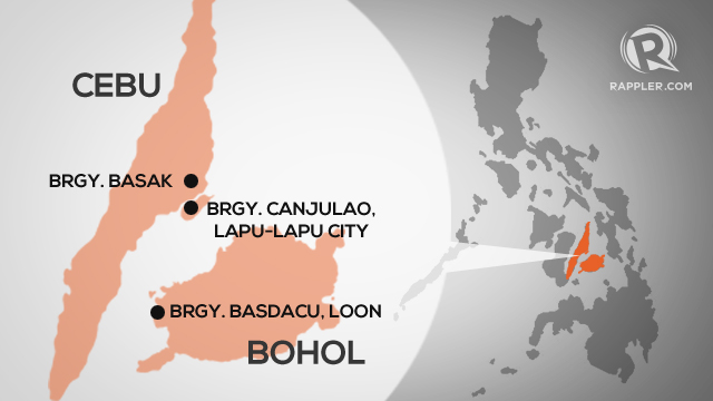
Before this, a sinkhole was also reported in Cebu, also in Central Visayas.
“We will be mapping the sinkholes present in Bohol province. The findings will be made available to local government units,” MGB Director Leo Jasareno said on Friday, October 18.
“They can use these to warn residents,” he added.
Sinkholes develop when limestone deposits underground are eroded by water. The natural depression caused by the erosion widened, Jasareno said.
Sun.Star Cebu reported that the sinkhole in Sitio Kapayas, Barangay Canjulao, in Lapu-Lapu City (Cebu province) is getting wider. Families have been evacuated.
In Loon, the hardest-hit town in Bohol, 6 sinkholes were reported in barangays Basak and Basdacu.
As of Friday afternoon, the death toll from the earthquake had reached at least 172. Authorities feared the number would still rise. – Rappler.com
Add a comment
How does this make you feel?
There are no comments yet. Add your comment to start the conversation.