SUMMARY
This is AI generated summarization, which may have errors. For context, always refer to the full article.

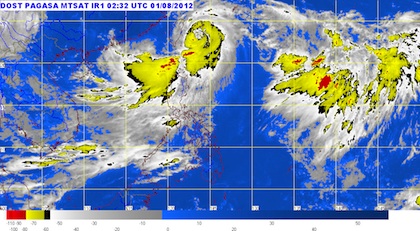
MANILA, Philippines – Taiwan is bracing for typhoon Gener (international codename Saola) as it intensifies on its way out of the Philippine Area of Responsibility (PAR) on Wednesday, August 1.
Gener was last spotted 380 kilometers north northeast of Basco, Batanes (24.0°N, 123.3°E) as of 4 pm, with maximum sustained winds of 130 km per hour near the center and gusts of 160 km/h.
It is now moving towards the north northwest, at a faster pace of 15 km/h.
The typhoon is expected to be 580 km north northwest of Basco by Thursday morning, or 80 km northeast of Taipei, outside the PAR.
Public storm warning signal number 2 is still in effect over Batanes, and the Calayan & Babuyan island groups of Cagayan.
Meanwhile, the rest of Cagayan and the province of Apayao are under public storm warning signal number 1.
Within the 800 km diameter of Gener, rainfall amounts are estimated to be heavy to torrential, at a rate of 10-35 millimeters per hour.
The typhoon has left 12 people dead, according to the National Disaster Risk Reduction and Management Council’s latest report.
The Southwest Monsoon will still be enhanced by Gener, bringing rain & moderate to strong winds over Luzon & Visayas, especially the western parts.
Residents in low-lying or mountainous areas are still in danger from landslides and flashfloods, the bureau said. People living near the coasts in areas affected by the typhoon are warned against storm surges and big waves.
Seas will still be rough in areas affected by the typhoon and monsoon, and small seacraft are advised not to go out to sea.
Meanwhile, the Low Pressure Area west of Batanes has weakened and was last reported by the Pagasa (3 pm Wednesday) as dissipating.
The bureau’s next severe weather bulletin will be released at 11 pm Wednesday. – Rappler.com
Add a comment
How does this make you feel?
There are no comments yet. Add your comment to start the conversation.