SUMMARY
This is AI generated summarization, which may have errors. For context, always refer to the full article.
MANILA, Philippines (UPDATED as of 2:40am, August 6) – The La Mesa dam has reached its spilling level while the alarm level at the Marikina River has been raised to Level 3 due to heavy rainfall in the past hours.
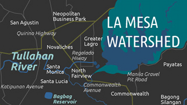
As of 2 a.m. on Monday, August 6, the La Mesa Dam water level has reached its spilling level of 80.15 meters. The dam is designed to overflow to one area, focused on the Tullahan River, so the affected areas will be parts of Fairview, Valenzuela, Navotas, Quezon City and Malabon.
An hour before, weather bureau Pagasa has noted flooding incidents at a nearby village.
La Mesa update: 1:00 AM elevation 80.14 m. There was a reported flooding at Northridge Subdivision, Fairview.
— PAGASA-FFWS (@PAGASAFFWS) August 5, 2012
The La Mesa dam is part of a system that supplies water to Metro Manila areas. The water that flows down the spillway goes to the Tullahan river and eventually empty into Manila bay.
Earlier, forced evacuation of residents has been strongly recommended to local governments in affected areas.
The heavy rain is still brought by the southwest monsoon, which affects Luzon and Visayas.

Marikina River
The heavy rainfall also caused the level in the Marikina River to rise.
As of 2 a.m. on Monday, August 6, the 3rd Alarm has been raised as the water lavel reached 17 meters already.
ABISO MARIKENYO> As of 2:00 a.m. ngayong August 6, 2012 ang water level po ng
— PIO Marikina (@MarikinaPIO) August 5, 2012#MarikinaRiver ay nasa 17 meters(3rd Alarm)
In less than two hours, at around 3:45 am, the Marikina local office said on Twitter that the water level has receded to 16.9-meter level.
Alarm Level 3 means residents are asked to voluntarily evacuate.
The local government of Marikina has earlier suspended classes at barangays Malanday, Tumana, Concepcion Uno, and Nangka since these became the designated evacuation areas.

Warning signal
Weather bureau Pagasa has maintained the green warning signal in Metro Manila after heavy rainfall was observed for the past hours.
GREEN WARNING SIGNAL: Issued at:1:00AM, 06 August 2012 (Monday)Target Areas:Metro ManilaHeavy rainfall ( (cont) tl.gd/imkn7h
— PAGASA-DOST (@dost_pagasa) August 5, 2012
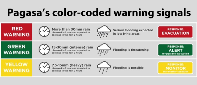
The state weather bureau has raised the signal to “green” at 10pm on Sunday, just right after the “yellow” warning was raised at 8:50pm.
The green warning signifies that flooding is threatening in low-lying areas and those located near the river channels, and that residents of these areas should be alert for possible evacuation.

Floods
Netizens in various parts of Metro Manila also posted updates, including pictures of flooding in their areas.
The National Disaster Risk Reduction and Management Council (NDRRMC) said in its 7pm bulletin that light to moderate rains will be expected in the next 24 hours. – Rappler.com
Add a comment
How does this make you feel?
There are no comments yet. Add your comment to start the conversation.