SUMMARY
This is AI generated summarization, which may have errors. For context, always refer to the full article.
What’s the weather like in your area? Tweet us the situation: Use #weatheralert and tag @rapplerdotcom
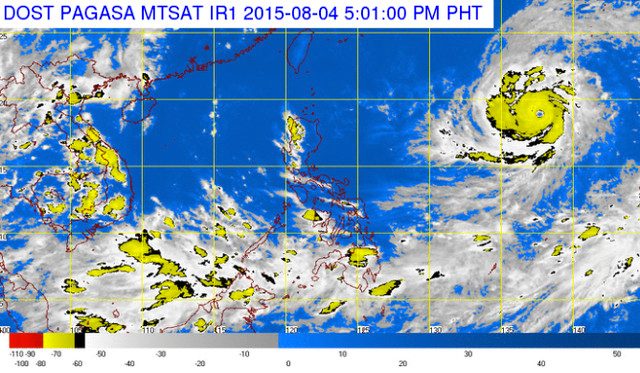
MANILA, Philippines – Typhoon Soudelor is expected to enter the Philippine Area of Responsibility (PAR) on the morning of Wednesday, August 5.
The Philippine Atmospheric, Geophysical, and Astronomical Services Administration (PAGASA) said Soudelor was 1,750 kilometers east of Luzon at 4 pm on Tuesday.
It packed maximum sustained winds of 215 kilometers/hour, with gusts of up to 250 km/h. It is expected to move west north west at a speed of 20 km/h.
Soudelor’s wind speeds are near super typhoon level. In PAGASA’s definition of super typhoons, maximum sustained winds should go over 220 km/h.
Once it enters the PAR, the storm will be given the name, “Hanna.”
Based on projections, Soudelor is unlikely to make landfall in the Philippines.
By Wednesday morning, it will be 1,400 kilometers east of Calayan Island in Northern Luzon. It will continue moving toward ocean waters off the coast of Batanes before exiting the PAR on Saturday morning, predicts PAGASA.
But the weather agency warned against complacency. Typhoon Soudelor is likely to enhance the Southwest Monsoon or Habagat, bringing stronger rains to Visayas and Mindanao.
Disaster officials are asked to monitor Soudelor’s movements.
Wednesday forecast
Light to moderate rains and a smattering of thunderstorms are likely in Mindanao, Western Visayas, and the province of Palawan on Wednesday.
Winds all over the country will be light to moderate, resulting in slight to moderate ocean waters. – Rappler.com
Add a comment
How does this make you feel?
There are no comments yet. Add your comment to start the conversation.