SUMMARY
This is AI generated summarization, which may have errors. For context, always refer to the full article.

MANILA, Philippines – Typhoon Nona (international name Melor) made its second landfall in Sorsogon on Monday afternoon, December 14, after hitting Batag, Northern Samar in the morning.
In its bulletin issued 5 pm on Monday, state weather bureau PAGASA said Typhoon Nona was already located over Bulusan, Sorsogon. It continues to move west at 17 kilometers per hour (km/h), heading for Burias Island.
Nona still has maximum winds of 150 km/h near the center and gustiness of up to 185 km/h.
Estimated rainfall amount is from heavy to intense within the 300-kilometer diameter of the typhoon.
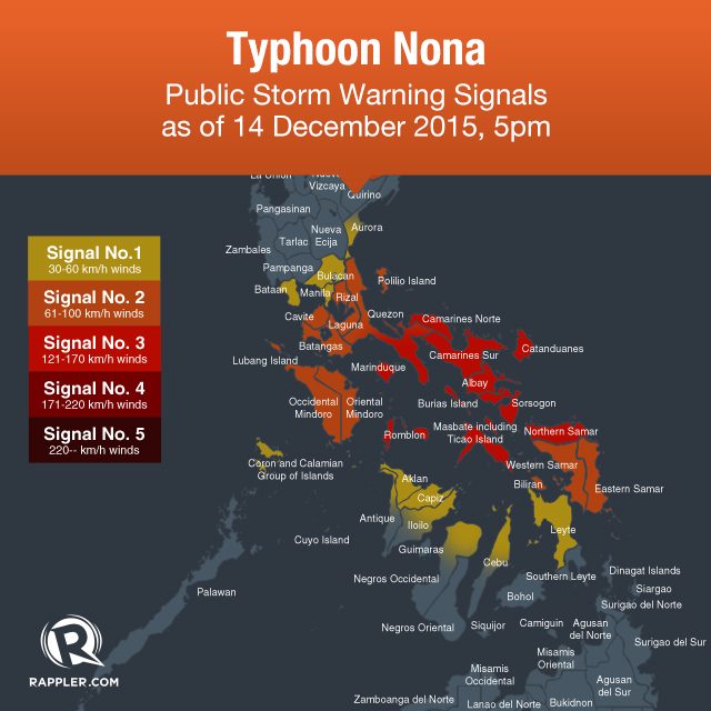
Storm warning signals are raised in parts of Luzon and Visayas.
Signal #3:
- Sorsogon
- Masbate including Ticao and Burias Islands
- Albay
- Camarines Sur
- Camarines Norte
- Catanduanes
- southern Quezon
- Marinduque
- Romblon
- Northern Samar
Signal #2:
- Batangas
- Rizal
- Laguna
- Cavite
- rest of Quezon including Polillo Island
- Oriental Mindoro
- Occidental Mindoro including Lubang Island
- Eastern Samar
- Samar
- Biliran
Signal #1:
- Metro Manila
- Bulacan
- Bataan
- Pampanga
- southern Zambales
- southern Aurora
- Coron
-
Leyte
-
northern Cebu including Bantayan and Camotes Islands
-
Aklan
-
Capiz
-
northern Antique
-
northern Negros Occidental
-
northern Iloilo
PAGASA warned of flash floods, landslides, and storm surges up to 3 meters high in areas under signals #2 and #3. Earlier, the weather bureau warned of storm surges up to 4 meters high.
Nona is expected to cross Burias Island on Monday night and pass over the Mindoro provinces on Tuesday afternoon, December 15.
The typhoon is expected to stay in the Philippine Area of Responsibility (PAR) until Friday, December 18. – Rappler.com
Add a comment
How does this make you feel?
There are no comments yet. Add your comment to start the conversation.