SUMMARY
This is AI generated summarization, which may have errors. For context, always refer to the full article.
What’s the weather like in your area? Report the situation through Rappler’s Agos or tweet us at @rapplerdotcom.
For the latest updates on Typhoon Lawin (Haima), go to our live blog
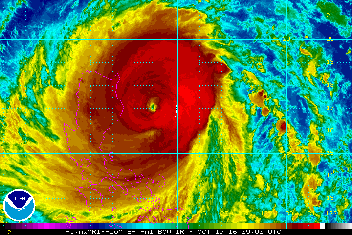
MANILA, Philippines – Super Typhoon Lawin (Haima) maintained its strength late Wednesday afternoon, October 19, as it continues to pose a serious threat to the Cagayan-Isabela area.
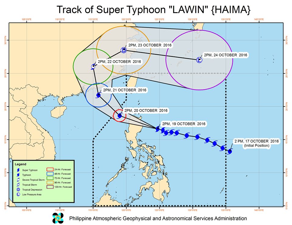
In its bulletin issued 5 pm on Wednesday, state weather bureau PAGASA said Lawin is now 275 kilometers east southeast of Tuguegarao City, Cagayan, moving west northwest at 25 kilometers per hour (km/h).
It still has maximum winds of up to 225 km/h and gustiness of up to 315 km/h.
Lawin is expected to make landfall in the Cagayan-Isabela area later around midnight and then cross Ilocos Norte and Apayao.
In a press briefing, PAGASA forecaster Aldczar Aurelio warned that the destruction could be close to what the Philippines experienced during the onslaught of Super Typhoon Yolanda (Haiyan) in November 2013.
“Ano po ang mararanasan po nila (areas under signal number 5)? Delubyo po. Hindi nalalayo sa pinsala ng Yolanda,” he said.
(What will areas under signal number 5 experience? It may be catastrophic, not far from the destruction caused by Yolanda.)
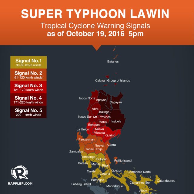
Below is the complete list of areas under warning signals.
Signal number 5:
- Cagayan
- Isabela
- Kalinga
- Apayao
Signal number 4:
- Ilocos Norte
- Ilocos Sur
- Abra
- Mt Province
- Ifugao
- Calayan Group of Islands
Signal number 3:
- La Union
- Benguet
- Nueva Vizcaya
- Quirino
- northern Aurora
Signal number 2:
- Batanes
- Pangasinan
- rest of Aurora
- Tarlac
- Nueva Ecija
- northern Zambales
- northern Quezon including Polillo Island
Signal number 1:
- rest of Zambales
- Bulacan
- Bataan
- Pampanga
- Rizal
- rest of Quezon
- Cavite
- Laguna
- Batangas
- Metro Manila
- Camarines Norte
- Camarines Sur
- Catanduanes
- Albay
Moderate to intense rain is expected within Lawin’s 800-km diameter.
PAGASA earlier said powerful winds experienced in areas under signal number 4 or 5 “can destroy high- to low-risk structures” as well as topple trees and transmission towers.
Storm surges up to 5 meters high are also possible in Cagayan (including the Calayan Group of Islands), Isabela, northern Aurora, and Ilocos Norte.
Sea travel is risky in the eastern seaboard of Southern Luzon and the northern and eastern seaboards of Samar.
Lawin is expected to leave the Philippine Area of Responsibility (PAR) either on Thursday night or early Friday, October 21.
– Rappler.com
Add a comment
How does this make you feel?
There are no comments yet. Add your comment to start the conversation.