SUMMARY
This is AI generated summarization, which may have errors. For context, always refer to the full article.

MANILA, Philippines – Storm warning signals were raised in the Batanes and Babuyan group of islands as Tropical Depression Fabian maintained strength on Saturday, July 22.
In its 11 am bulletin, state weather bureau PAGASA said that the center of Fabian was located at 170 kilometers west northwest of Basco, Batanes as of 10 am.
Fabian packs maximum winds of up to 55 km/hr near the center and gustiness of up to 65 km/hr. It is forecast to move west northwest at 18 km/hr.
Rainfall amount is estimated to be moderate to heavy within the 200-km diameter of the tropical depression.
Evolving from a low pressure area (LPA) early Saturday morning, Fabian is expected to leave the Philippine Area of Responsibility (PAR) on Saturday evening, added PAGASA.
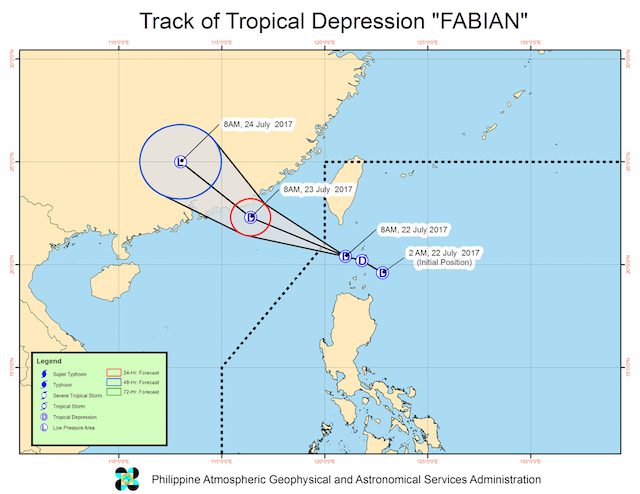
Northern Cagayan was earlier placed under Signal Number 1, but the storm warning signal there was lifted in PAGASA’s 11 am bulletin.
Meanwhile, PAGASA said that an LPA was spotted at 725 kms east of Hinatuan, Surigao del Sur, at 8 am.
The said LPA will bring cloudy skies with light to moderate rain over Eastern Visayas, Northern Mindanao, Caraga, and Davao regions.
PAGASA’s next weather bulletin will be at 5 pm Saturday. – Rappler.com
Add a comment
How does this make you feel?
![[ANALYSIS] A new advocacy in race to financial literacy](https://www.rappler.com/tachyon/2024/04/advocacy-race-financial-literacy-April-19-2024.jpg?resize=257%2C257&crop_strategy=attention)


![[In This Economy] Can the PH become an upper-middle income country within this lifetime?](https://www.rappler.com/tachyon/2024/04/tl-ph-upper-income-country-04052024.jpg?resize=257%2C257&crop=295px%2C0px%2C720px%2C720px)

There are no comments yet. Add your comment to start the conversation.