SUMMARY
This is AI generated summarization, which may have errors. For context, always refer to the full article.

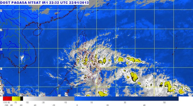
MANILA, Philippines – A low pressure area is currently hovering south of Mindanao, as many areas on the island are forecast to receive more rain Wednesday, January 23.
The low pressure area was last spotted 300 km southeast of General Santos City, state weather bureau PAGASA said.
Caraga, Davao, Soccsksargen, Northern Mindanao and Eastern Visayas will have cloudy skies with moderate to heavy rain, the bureau said, possibly triggering landslides and floods in these areas.
The remaining areas of Visayas and Mindanao will have light to moderate rain or thunderstorms.
As the northeast monsoon continues to affect Luzon, Bicol, Calabarzon, Metro Manila, Cagayan Valley, and Aurora and Quezon provinces will have cloudy skies with light rain.
The rest of the archipelago will have partly cloudy skies with brief light rain, the bureau added.
Prevailing winds will be mainly coming from the northeast.
PAGASA 24-Hour Public Weather Forecast, 23 January 2013, 5am
– Rappler.com
Add a comment
How does this make you feel?


There are no comments yet. Add your comment to start the conversation.