SUMMARY
This is AI generated summarization, which may have errors. For context, always refer to the full article.
UPDATE: Click here for the latest Typhoon Labuyo update (Monday AM, August 12).
What’s the weather like in your area? Tweet us the situation: Use #weatheralert and tag @rapplerdotcom.
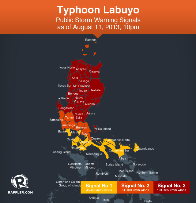
MANILA, Philippines (UPDATED) — Nearly the entire northern Luzon was placed under storm warning signal number 3 as Typhoon Labuyo (international codename Utor) intensified further Sunday evening, August 11.
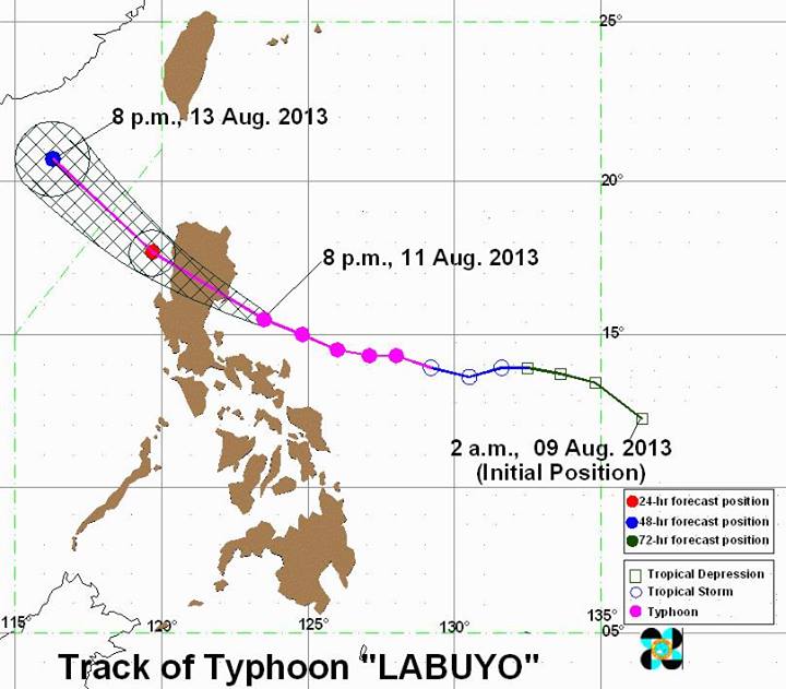
Labuyo was 110 kilometers southeast of Casiguran, Aurora (15.6°N, 123.1°E), as of 10 pm, carrying maximum sustained winds of 175 km/h and gusts of up to 210 km/h.
The bureau said it is still moving at a speed of 19 km/h west-northwest, state weather bureau PAGASA announced in a 10 pm press conference aired live from its headquarters in Quezon City.
The typhoon is still forecast to make landfall in the general area of Aurora and Isabela early Monday morning, August 12. It will traverse northern Luzon Monday, and is forecast to be 100 km southwest of Laoag City. It is expected to exit the Philippine Area of Responsibility (PAR) by Tuesday, August 13.
Rainfall within the typhoon’s 600 km diameter is estimated to be heavy to intense (10-25 mm/h).
Storm warning signal number 3 has been raised over the following areas:
- Cagayan
- Isabela
- Aurora
- Polillo Island
- Nueva Ecija
- Nueva Vizcaya
- Quirino
- Abra
- Ifugao
- Mountain Province
- Kalinga
- Apayao
- Benguet
- Ilocos Norte
- Ilocos Sur
- La Union
- Pangasinan
Here, winds between 101-185 km/h is expected within 18 hours. Heavy damage to agriculture and property is possible, along with moderate to heavy disruption to communications and power systems. Any type of travel – land, sea, or air – is dangerous.

Storm warning signal number 2, where winds between 61-100 km/h can be expected within 24 hours, is in effect over the following areas:
- Northern Quezon
- Rizal
- Bulacan
- Pampanga
- Tarlac
- Zambales
- Calayan and Babuyan Islands
These areas can expect moderate damage to agriculture, as well as to structures made of light materials. Travel by air or sea is risky.
Storm warning signal number 1, meanwhile, is in effect over the following areas:
- Cavite
- Batangas
- Laguna
- Rest of Quezon
- Camarines Norte
- Camarines Sur
- Catanduanes
- Batanes
- Bataan
- Metro Manila
These places can expect winds 45-60 km/h within the next 36 hours.
Some damage to agriculture may be experienced, and structures made of light materials may be partially damaged. Small seacraft are advised to stay ashore in these areas.
The storm warning signals in other areas have been lifted, the bureau said.
In all areas under storm warning signals, flash flooding, landslides, and storm surges are possible, and residents are warned to be on the lookout for these.
Foreign weather bureaus: Super typhoon status
“Ito po ang pinakamalakas na bagyo so far this year… na tatama sa kalupaan” (It is the strongest typhoon to make landfall this year), PAGASA OIC Director Vicente Malano said in PAGASA’s 11 am press conference.
Foreign meteorologists and weather bureaus have pegged Labuyo as a very strong typhoon in their respective forecasts.
The US Navy’s Joint Typhoon Warning Center and the Hong Kong Observatory (HKO) both have labeled Labuyo/Utor as a super typhoon, while the Japan Meteorological Agency (JMA) warned the typhoon will is “violent.”
Weather Underground meteorologist Jeff Masters has labeled the typhoon as “Earth’s most dangerous tropical cyclone so far in 2013,” reporting it as equivalent to a Category 4 tropical cyclone in the Saffir-Simpson Hurricane Scale used in the Western Hemisphere.
Under the said scale, a Category 4 storm will bring “catastrophic damage.”
Earlier, the bureau said it sent a storm-chasing team to monitor the typhoon in Aurora, and will coordinate with the local disaster risk reduction management council there, Malano said.
After passing through the Philippines, it is expected to move towards the southern coast of China and northern Vietnam later this week.
Labuyo will continue to enhance the southwest monsoon, bringing rain to the rest of the country.
The next PAGASA update is at 5 am Monday. – Rappler.com
UPDATE: Click here for the latest Typhoon Labuyo update (Monday AM, August 12).
Add a comment
How does this make you feel?
There are no comments yet. Add your comment to start the conversation.