SUMMARY
This is AI generated summarization, which may have errors. For context, always refer to the full article.
UPDATE: Click here for the latest Typhoon Labuyo update (Monday afternoon, August 12).
What’s the weather like in your area? Tweet us the situation: Use #weatheralert and tag @rapplerdotcom.
MANILA, Philippines — Typhoon Labuyo (international codename Utor) has weakened and slowed down as it crossed northern Luzon Monday morning, August 12.
The typhoon was spotted in the vicinity of Baguio City (16.7°N, 120.6°E) as of 10 am, state weather bureau PAGASA said, carrying maximum sustained winds of 140 km/h, and gusts of up to 170 km/h.
Moderate to heavy rainfall (7-15 mm/h) is expected within the typhoon’s 500 km diameter, the bureau said.
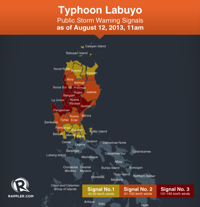
Click here for PAGASA’s Severe Weather Bulletin No. 12 on Typhoon Labuyo
Storm warning signal #3 is still in effect over the following areas:
- Quirino
- Nueva Vizcaya
- Ifugao
- Mountain Province
- Ilocos Sur
- Benguet
- La Union
- Pangasinan
Signal #2, meanwhile, is in effect over the following areas:
- Isabela
- Aurora
- Southern Cagayan
- Kalinga
- Abra
- Southern Ilocos Norte
- Zambales
- Tarlac
- Nueva Ecija
Storm signal #1 is hoisted over the following areaa:
- Rest of Cagayan
- Apayao
- Rest of Ilocos Norte
- Babuyan and Calayan group of islands
- Pampanga
- Bulacan
- Bataan
- Rizal
- Northern Quezon including Polilio Is
- Metro Manila
Flash flooding, landslides, and storm surges are possible in all areas under storm warning signals.
The storm signals in other areas have been lifted, the bureau said.

Labuyo is expected to be over the West Philippine Sea by early Monday afternoon, and is forecast to move west northwest at a speed of 19 km/h.
It is forecast to be 360 km west of Sinait, Ilocos Sur by Tuesday morning, August 13, or outside the Philippine Area of Responsibility.
The typhoon, PAGASA said, is the strongest so far this year, in terms of wind speed, while foreign weather bureaus and meteorologists have categorized it as a super typhoon just prior to landfall.
After passing through the Philippines, it is expected to move towards the general area of southeast China and northern Vietnam.
Labuyo will also continue to enhance the southwest monsoon, bringing rain to the rest of the country.
The next PAGASA update is at 5 pm. – Rappler.com
Add a comment
How does this make you feel?
There are no comments yet. Add your comment to start the conversation.