SUMMARY
This is AI generated summarization, which may have errors. For context, always refer to the full article.

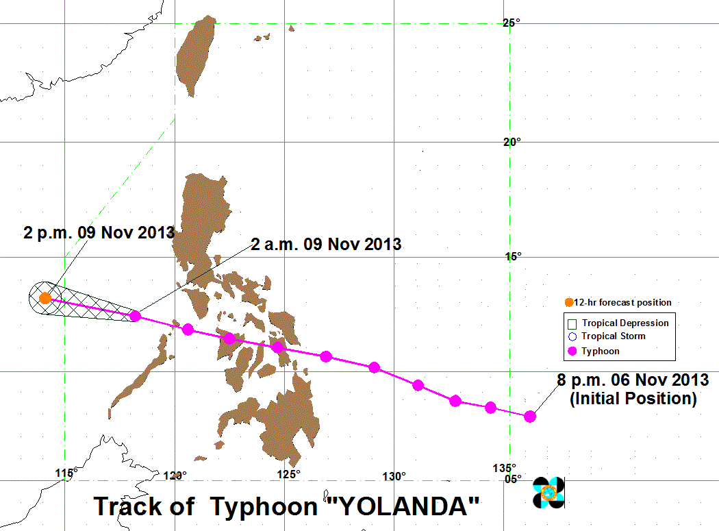
MANILA, Philippines – Typhoon Yolanda (international codename Haiyan) weakened further overnight as it continues to move away from the country Saturday, November 9, and is still on track to exit the Philippine Area of Responsibility (PAR).
As of 4 am Saturday, Yolanda was located 405 kilometers west of San Jose, Occidental Mindoro, carrying maximum sustained winds of 175 kilometers per hour near the center and gusts of up to 210 km/h.
It is still carrying heavy to intense rainfall within its 400 km diameter, state weather bureau PAGASA said in its 5 am severe weather bulletin.
Public storm warning signals number 4 and 3 have been lowered. The highest storm warning signal in place is signal number 2, and is hoisted over extreme northern Palawan and the Calamian islands.
Signal number 1, on the other hand, is raised over the following areas:
- Northern Aklan including Boracay Island
- Northern Antique inculding Semirara Island
- Occidental Mindoro and Lubang Island
- Oriental Mindoro
- Romblon
- Marinduque
- Batangas
- Northern Palawan including Puerto Princesa City and Cuyo Island
Public storm warning signals in other areas are now lowered, the bureau said.
The typhoon is expected to still move west northwest, at a speed of 35 km/h, and will be 760 km west northwest of San Jose by this afternoon.
It is then expected to cross the South China Sea (West Philippine Sea) on its way to Vietnam.
Residents in areas still under storm signals should be on the lookout for possible flash floods and landslides, as well as storm surges along coastal areas.
Sea travel is still risky in these areas, as well as in northern and central seaboards of Luzon, and the eastern coasts of Luzon and Visayas.
The next bulletin on Yolanda will be issued by the bureau at 11 am Saturday.
One of the most intense typhoons on record, it whipped across the central parts of the country for most of Friday, November 8, killing at least 6 people and terrifying millions as monster winds tore apart homes.
Yolanda smashed into coastal communities on the central island of Samar before dawn on Friday with maximum sustained winds of about 235 km/h and gusts of up to 275 km/h, according to PAGASA. Foreign meterologists said it hit land with winds of 315 km/h, one of the strongest ever recorded.
It then swept across the Visayas, destroying phone and power lines, as well as homes and vital infrastructure, causing a massive communications blackout that left authorities without a clear idea of the extent of the damage.
“It was frightening. The wind was so strong, it was so loud, like a screaming woman. I could see trees being toppled down,” said Liwayway Sabuco, a saleswoman from Catbalogan City in Samar.
The death toll was expected to rise, with disaster relief officials particularly concerned for isolated communities in Leyte and Samar provinces. – With reports from Agence France-Presse/Rappler.com
Add a comment
How does this make you feel?
There are no comments yet. Add your comment to start the conversation.