SUMMARY
This is AI generated summarization, which may have errors. For context, always refer to the full article.
What’s the weather like in your area? Tweet us the situation: Use #weatheralert and tag @rapplerdotcom
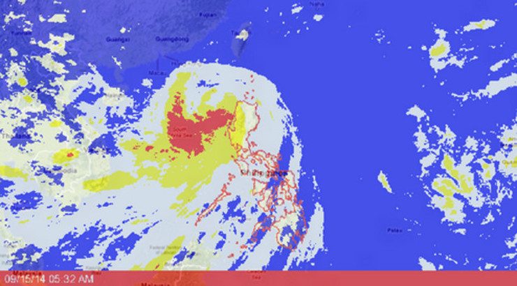
MANILA, Philippines (3RD UPDATE) – Storm Warning Signals have been lowered in 7 areas as Typhoon Luis (Kalmaegi) made its way out of the Philippine Area of Responsibility on Monday, September 15.
As of 4 am Monday, the eye of the typhoon was located in the West Philippine Sea. It was spotted 100 kilometers West Northwest of Laoag, Ilocos Norte, state weather bureau PAGASA said.
The typhoon is carrying maximum sustained winds of 120 kilometers per hour and gusts of up to 150 km/h. It is moving west northwest at a speed of 30 km/h.
Typhoon Luis is expected to be outside the Philippine area of responsibility Monday morning, PAGASA added. It is expected to be at 811 km West Northwest of Laoag City by Monday evening.
Public storm warning signal number 3 is in effect in this area:
- Ilocos Norte
It should expect winds of 101-185 km/h in at least 18 hours.
Signal number 2, where winds between 61-100 km/h can be felt in the next 24 hours, has been hoisted in the following places:
- Cagayan, including Babuyan and Calayan Islands
- Apayao
- Kalinga
- Abra
- Mountain Province
- Ilocos Sur
Signal number 1, meanwhile, is in effect in these area:
- Isabela
- Ifugao
- Nueva Vizcaya
- Benguet
- La Union
- Pangasinan
- Batanes Islands

People in these areas should expect winds between 30-60 km/h in the next 36 hours.
“Residents in low lying and mountainous areas under signal #3, #2 and #1 are alerted against possible flash floods and landslides. Likewise, those living in coastal areas under signal #3 and #2 are alerted against storm surges of up to 2 meters,” PAGASA warned.
Gale warnings are in effect in the eastern and western seaboards of Luzon.
Fishing boats and other small seacrafts should not venture out over the seaboards of Luzon and the western and central seaboards of Visayas.
Because of Luis, seas in Ilocos Norte, Apayao, Abra, Kalinga, Mountain Province Ilocos Sur, Cagayan, Babuyan and Calayan Islands will be rough to very rough, said PAGASA in their 5 am weather forecast.
Metro Manila and the rest of Luzon will experience monsoon rains which may trigger flashfloods and landslides.
Floods, landslides, storm surges
At least three towns in the direct path of the storm have initiated a “pre-emptive evacuation”, with other vulnerable areas being told to brace for flash floods and landslides, the National Disaster Risk Reduction and Management Council (NDRRMC) said.
“I am calling on our countrymen… take proper precautions for your situation and listen to the warnings of your village leaders. Do not wait for the storm to hit you,” NDRRMC chief Alexander Pama said in a live television broadcast earlier Sunday.
He warned that the typhoon might bring storm surges as high as two meters (6.5 feet) to coastal areas.
Such storm surges – referring to tsunami-like walls of water driven inland by wind from the sea – were blamed for many of the nearly 8,000 people left dead or missing when Super Typhoon Haiyan (Yolanda) devastated large parts of the country last year.
Even people who had taken refuge in government evacuation centers drowned as the water caught many unaware. – Rappler.com
Stay alert and ready with the latest weather and disaster information through Project Agos.
Add a comment
How does this make you feel?


![[WATCH] Try This: Empanada Salteña from Argentina](https://www.rappler.com/tachyon/2023/04/try-this-empanada-saltena-argentina.jpg?resize=257%2C257&crop=765px%2C0px%2C1037px%2C1037px)


There are no comments yet. Add your comment to start the conversation.