SUMMARY
This is AI generated summarization, which may have errors. For context, always refer to the full article.
What’s the weather like in your area? Tweet us the situation: Use #weatheralert and tag @rapplerdotcom
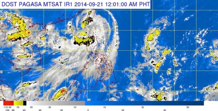
MANILA, Philippines (2nd UPDATE) – Tropical Storm Mario (Fung-Wong) maintained its strength on Saturday evening, September 20, as it continues to move toward southern Taiwan, said state weather bureau PAGASA.
As of 11 pm Saturday, the center of Mario was spotted at 186 km west northwest of Itbayat, Batanes.
The tropical storm packs maximum sustained winds of 95 km per hour near the center and gustiness of up to 120 km per hour. It is seen to move north northeast at 17 km per hour, with moderate to heavy rains (7 to 15 mm per hour) within its 450-km diameter.
PAGASA has placed the following areas under public storm warning signal number 2:
- Batanes Group of Islands
These areas will have stormy weather with rough to very rough seas.
Meanwhile, public storm warning signal number 1 is raised over:
- Calayan and Babuyan Group of Islands
- Apayao
- Ilocos Norte
- Abra
In these areas, rains with gusty winds will be experienced, with moderate to rough seas.
The combined effect of Mario and the southwest monsoon will bring moderate to occasionally heavy rains and thunderstorms – which may trigger flashfloods and landslides – as well as moderate to strong winds over Zambales, Bataan, and the rest of northern Luzon, said PAGASA.
Meanwhile, the rest of Central Luzon will have occasional rains. The rest of the country will be partly cloudy to cloudy, with isolated rainshowers or thuderstorms.
Mario is expected to be at 433 km north northwest of Itbayat, Batanes (or in the vicinity of northern Taiwan) by Sunday evening, September 21; and at 791 km north of Itbayat – or outside the Philippine Area of Responsibility (PAR) – by Monday evening, September 22.
The next bulletin for Mario will be issued at 5 am Sunday.
Here is PAGASA’s weather forecast for Sunday:
| City | Forecast | Temperature Range |
|
| Metro Manila |  |
Occasional rains | 24°C-31°C |
| Tuguegarao |  |
Rains with gusty winds | 24°C-29°C |
| Laoag |  |
Stormy | 25°C-28°C |
| Baguio |  |
Monsoon rains | 15°C-20°C |
| Subic/Olongapo; Clark/Angeles | |
Occasional rains | 22°C-29°C |
| Tagaytay | |
Occasional rains | 20°C-28°C |
| Lipa | |
Occasional rains | 24°C-31°C |
| Legazpi |  |
Partly cloudy to cloudy skies with isolated rainshowers or thunderstorms |
25°C-32°C |
| Puerto Princesa | |
Partly cloudy to cloudy skies with isolated rainshowers or thunderstorms |
24°C-32°C |
| Iloilo/Bacolod | |
Partly cloudy to cloudy skies with isolated rainshowers or thunderstorms |
25°C-32°C |
| Metro Cebu | |
Partly cloudy to cloudy skies with isolated rainshowers or thunderstorms |
24°C-32°C |
| Tacloban | |
Partly cloudy to cloudy skies with isolated rainshowers or thunderstorms |
24°C-32°C |
| Cagayan de Oro | |
Partly cloudy to cloudy skies with isolated rainshowers or thunderstorms |
21°C-32°C |
| Metro Davao | |
Partly cloudy to cloudy skies with isolated rainshowers or thunderstorms |
25°C-32°C |
| Zamboanga | |
Partly cloudy to cloudy skies with isolated rainshowers or thunderstorms |
24°C-33°C |
– Rappler.com
Add a comment
How does this make you feel?
There are no comments yet. Add your comment to start the conversation.