SUMMARY
This is AI generated summarization, which may have errors. For context, always refer to the full article.
What’s the weather like in your area? Tweet us the situation: Use #weatheralert and tag@rapplerdotcom
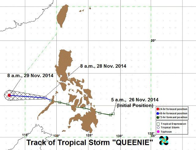
MANILA, Philippines (UPDATED) – State weather service PAGASA reports that tropical cyclone Queenie (Sinlaku) has intensified into a tropical storm while over the West Philippine Sea.
As of 10 am of Friday, November 28, Tropical Storm Queenie was estimated to be some 220 kilometers north-northwest of Puerto Princesa City. It is carrying maximum sustained winds of 65 km/h near the center, and gustiness of up to 80 km/h.
Tropical storm Queenie is expected to move West-Northwest at 26 km/h, and should be exiting the western border of the Philippine Area of responsibility (PAR) by 9 to 10 pm tonight.
Signal Number 1 has been placed over Palawan, including the Calamian Group of Islands. Those in the area should expect 7 to 15 mm of rain per hour within the 300 kilometer diameter of the tropical storm. Residents of low-lying or mountainous areas should take note against possible flashfloods and landslides.

Meanwhile, a low-pressure area was estimated to be 770 kiometers east of Davao City. This low-pressure area is expected to bring moderate to heavy rains, as well as thunderstorms, over Mindanao and Eastern and Central Visayas over the next 24 hours. – Rappler.com
Add a comment
How does this make you feel?
There are no comments yet. Add your comment to start the conversation.