SUMMARY
This is AI generated summarization, which may have errors. For context, always refer to the full article.
What’s the weather like in your area? Tweet us the situation: Use #weatheralert and tag @rapplerdotcom
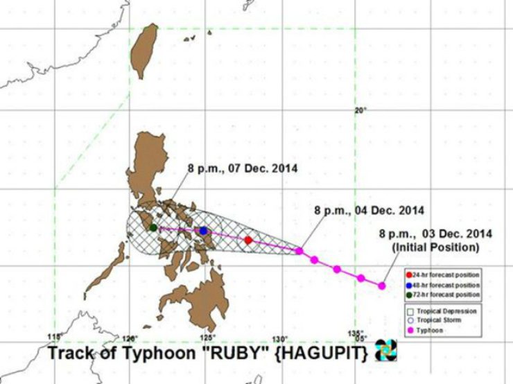
MANILA, Philippines – Typhoon Ruby (international name: Hagupit) maintained its strength Thursday evening, December 4, moving toward Eastern Visayas with winds of up to 205 kph and gustiness of up to 240 kph.
Ruby is expected to move at 15 kph and will be at 270 km east of Borongan, Eastern Samar, by Friday evening, December 5.
It is expected to make landfall by Saturday evening, December 6, over the Eastern Samar-Northern Samar area.
It is expected to be at 65 km East of San Jose, Occidental Mindoro, by Sunday evening, December 7.
Warning against moderate damage to agriculture and risky sea and air travel, PAGASA raised public storm warning signal number 2 over 9 areas:
- Northern Samar
- Eastern Samar
- Samar
- Biliran
- Leyte
- Southern Leyte
- Dinagat Island
- Surigao del Norte
- Siargao Island
Meanwhile, public storm warning signal number 1 has been raised over 10 areas:
- Catanduanes
- Albay
- Sorsogon
- Masbate including Ticao Island
- Cebu City
- Northern Cebu, including Bantayan Island and Camotes Island
- Bohol
- Surigao del Sur
- Camiguin Island
- Agusan del Norte
Rice and corn will be adversely affected with a few large trees uprooted in areas with storm signal warnings. A large number of nipa and cogon houses may be partially or totally unroofed and some old galvanized iron roofing may roll off.
Areas under public storm warning signals can expect moderate to heavy rains in the next 24 to 36 hours. PAGASA warned residents in low lying and mountainous areas against possible flashfloods and landslides, while storm surges are possible for those living near coastal areas.
Project NOAH executive director Mahar Lagmay earlier said storm surges of 3.5 to 4 meters are expected in parts of Eastern Visayas, and the highest surges are likely in Catarman, Borongan, and Guiuan in Eastern Samar and the Tacloban Straight in Leyte.
The typhoon and a northeast monsoon will bring rough to very rough sea conditions over the seaboards of Northern Luzon, eastern seaboard of Central Luzon and Southern Luzon, over the seaboards of the Visayas and over the northern and eastern seaboards of Mindanao.
“Fisherfolks and those using small seacraft are advised not to venture out over the said seaboards,” PAGASA said.
It advised the public and the disaster risk reduction and management council to take appropriate actions and watch for the next bulletin to be issued at 5 am on Friday. – Rappler.com
Stay alert and ready with the latest weather and disaster information through Project Agos.
Add a comment
How does this make you feel?
There are no comments yet. Add your comment to start the conversation.