SUMMARY
This is AI generated summarization, which may have errors. For context, always refer to the full article.
MANILA, Philippines (UPDATED) – A total of 47 provinces – home to 66.6 million Filipinos – have been identified by government scientists Friday, December 5, as high-risk areas when Typhoon Ruby (Hagupit) hits the country over the weekend.
As of 3 pm, the typhoon was located 380 kilometers east of Borongan, Eastern Samar, with maximum sustained winds of 195 km/h near the center, and gusts of up to 230 km/h, state weather bureau PAGASA said in a press conference at their headquarters in Quezon City.
The storm is being affected by the northeast monsoon, which is bringing cooler air from the northern polar regions of Asia, which caused the typhoon to lose some strength, state forecasters said.
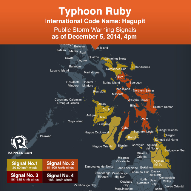
Public storm warning signal numbers 2 and 1 has been raised over these areas:
|
Signal no. 2 Winds between 61-100 km/h within 24 hours |
Signal no. 1 Winds between 30-60 km/h within 36 hours |
|
Albay |
Catanduanes |
| Sorsogon |
Camarines Norte |
|
Masbate |
Burias Island |
|
Ticao Island |
Romblon |
|
Northern Samar |
Capiz |
|
Eastern Samar |
Iloilo |
|
Samar |
Antique |
|
Biliran |
Guimaras |
|
Leyte |
Aklan |
|
Southern Leyte |
Negros Occidental |
|
Northern Cebu and Cebu City |
Negros Oriental |
|
Bantayan Island |
Rest of Cebu |
|
Camotes Island |
Siquijor |
|
Bohol |
|
| Surigao del Norte | |
| Surigao del Sur | |
| Agusan del Norte | |
| Agusan del Sur | |
| Camiguin | |
| Dinagat Island | |
| Siargao Island | |
| Rice and corn maybe adversely affected Few large trees uprooted Large number of nipa and cogon houses partially or totally unroofed and old galvanized iron roofs may roll off Billboards/Signage may roll off Travel by all types of sea vessels and aircrafts are risky Residents in low lying and mountainous areas are alerted against possible flash floods and landslides |
Twigs and branches of trees maybe broken Some banana plants may tilt or land flat on the ground Rice in flowering stage may suffer significant damage Some nipa and cogon houses maybe partially unroofed Sea travel of small sea crafts and fishing boats is risky Occasional rains with occasional gusty winds |
The bureau said they might raise public storm warning signal number 4 once the typhoon hits land, but said it will only be done within 12 hours of the predicted landfall.
Earlier Friday, the US Navy’s Joint Typhoon Warning Center (JTWC) has downgraded the system from super typhoon to typhoon. During the 4 pm briefing, PAGASA officials also declared Ruby as below super typhoon status.
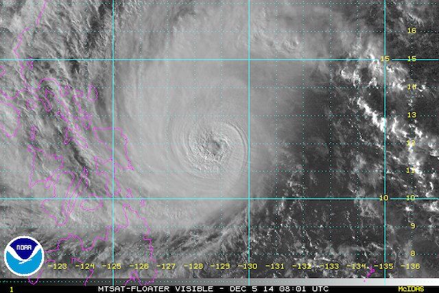
Heavy to intense rainfall (7.5-20 mm/h) is expected within the typhoon’s 600 kilometer diameter.
PAGASA listed 47 provinces across the country as “potential high-risk areas.” These are the provinces that are likely to be affected by the typhoon’s 600 kilometer diameter, the bureau explained.
|
POTENTIAL HIGH-RISK AREAS As of 4 pm, 5 December 2014 |
|
|
Aklan |
Albay |
|
Antique |
Aurora |
| Bataan |
Batangas |
|
Benguet |
Biliran |
| Bohol | Bulacan |
|
Camarines Norte |
Camarines Sur |
|
Capiz |
Catanduanes |
|
Cavite |
Cebu |
|
Dinagat Island |
Eastern Samar |
|
Guimaras |
Iloilo |
|
La Union |
Laguna |
|
Leyte |
Marinduque |
|
Masbate |
Metro Manila |
|
Negros Occidental |
Negros Oriental |
|
Northern Samar |
Nueva Ecija |
|
Nueva Vizcaya |
Occidental Mindoro |
|
Oriental Mindoro |
Palawan |
|
Pampanga |
Pangasinan |
|
Quezon |
Quirino |
|
Rizal |
Romblon |
|
Samar |
Sorsogon |
|
Southern Leyte |
Surigao del Norte |
|
Surigao del Sur |
Tarlac |
| Zambales | |
These provinces are home to a total ot 66.6 million Filipinos, based on 2010 census data from the Philippine Statistical Authority.
At highest risk are the areas where the storm’s eye might potentially pass close.
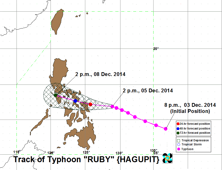
Ruby is still moving towards the west-northwest at a speed of 13 km/h. PAGASA said landfall is forecast in the area of Eastern Samar and Northern Samar by Saturday evening, December 6, or early Sunday, December 7.
It is expected to exit the Philippine Area of Responsibility (PAR) by Wednesday, December 10.
“Ruby and the Northeast Monsoon will bring rough to very rough sea conditions over the seaboards of Northern Luzon, eastern seaboard of Central and Southern Luzon, seaboards of Visayas and over northern and eastern seaboards of Mindanao,” the bureau said in its severe weather bulletin.
Metro Manila will likely be affected by Sunday, the bureau said, with the typhoon’s outer periphery affecting the metropolis. The area should expect possible rain and winds, but not as strong as those under storm signals 2 and 3, the bureau added.
The next bulletin will be released at 11 pm. – Rappler.com
Add a comment
How does this make you feel?
There are no comments yet. Add your comment to start the conversation.