SUMMARY
This is AI generated summarization, which may have errors. For context, always refer to the full article.
What’s the weather like in your area? Tweet us the situation: Use #weatheralert and tag @rapplerdotcom
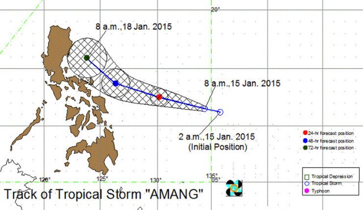
MANILA, Philippines (UPDATED) – Based on available data, chances are high that Tropical Storm Amang (international name Mekkhala) will not make landfall in the Philippines, according to the weather forecasters of state weather agency PAGASA.
In a press conference on Thursday, January 15, PAGASA weather specialist Christopher Perez said that Amang may skirt the eastern seaboard of Visayas and Luzon but not make landfall. However, Amang may still bring heavy to intense rain to areas within its 300-kilometer diameter within the next few days.
“Based on the current data, we do not expect it to make landfall inside PAR (Philippine Area of Responsibility),” said PAGASA administrator Vicente Malano.
At 10 am on Thursday, the center of Amang was spotted 905 kilometers east of Guiuan, Eastern Samar. It packs winds with speeds of 65 kilometers per hour (km/h) to 90 km/h. It is likely to move west northwest at a speed of 19 km/h.
Weather during papal visit
Given the forecast, the visit of Pope Francis to the country is likely to be accompanied by rain.
In a special weather outlook for the papal visit, PAGASA said Metro Manila is likely to have “generally good weather” with passing light rains from Thursday to Saturday, January 17.
On Sunday (January 18), the day of the Pope’s public mass at Quirino Grandstand, attendees can expect light rains. On Monday (January 19), when the Pope is expected to depart for Rome, Metro Manila will experience light rains and moderate winds.
When the Pope visits Tacloban City on Saturday, expect light to moderate rains brought by Amang. This is the day when Amang is expected to be the nearest the Samar and Leyte area.
Attendees to his public events in the Eastern Visayas city should also brace for moderate to strong winds.
But independent weather group Weather Philippines had a grimmer forecast. In its January 15 afternoon update, it said “heavy rains” may fall over Tacloban City and the rest of Northeastern Leyte, Samar, Eastern and Southern Bicol from Friday (January 16) to Sunday morning.
Amang may weaken into a tropical depression during the last few days of the Pope’s visit, said Perez.
This is because as Amang nears land, the cool winds from the Northeast Monsoon currently affecting the country, may help counteract the storm’s strength.
Malano said that, as of the moment, the storm’s strength does not warrant the raising of any public storm warning signal.
This means the storm is unlikely to be a major disruption during the Pope’s visit, he said.
But there is still a possibility that Amang may change course and make landfall, bringing more rain and stronger winds than expected. US weather station Joint Typhoon Warning Center (JTWC) predicts Amang will make landfall in Luzon on Monday.
If Amang stays on its current track, the storm may be outside PAR by Tuesday, January 20, or Wednesday, January 21.
Malano said there will be more conclusive data by 5 pm, Thursday. – Rappler.com
Add a comment
How does this make you feel?
There are no comments yet. Add your comment to start the conversation.