SUMMARY
This is AI generated summarization, which may have errors. For context, always refer to the full article.
What’s the weather like in your area? Tweet us the situation: Use #weatheralert and tag @rapplerdotcom
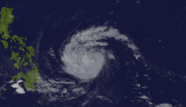
MANILA, Philippines (2nd UPDATE) – Typhoon Noul entered the Philippine Area of Responsibility (PAR) around 5 am on Thursday, May 7, and has now been given the name “Dodong.”
Dodong has slightly intensified, packing maximum sustained winds of 140 kilometers/hour with gusts of 170 km/h, state weather bureau PAGASA said in a news conference at around 9:30 am, and in its latest bulletin at 11 am.
The first Dodong bulletin reported that the typhoon was packing maximum sustained winds of 130 km/hour with gusts of 160 km/h.
At 10 am, it was spotted 925 kilometers east northeast of Surigao City. The weather system as a whole is moving faster. It is forecasted to move west northwest at a speed of 17 km/h.
In its latest bulletin, PAGASA said that the “estimated rainfall amount is from heavy to intense within the 300 km diameter of the typhoon” which is “expected to affect the eastern Visayas and Bicol region for the next 24-36 hours.”
Given Dodong’s pattern of intensifying, there is a possibility that it will develop into a super typhoon, said PAGASA weather forecaster Fernando Cada.
A forecast by independent weather monitoring group Weather Philippines shows it may become a super typhoon by Saturday, May 9.
Their track prediction shows Dodong with wind speeds of 195 to 230 km/h on that day. PAGASA defines a super typhoon as a weather system with winds of more than 220 km/h.
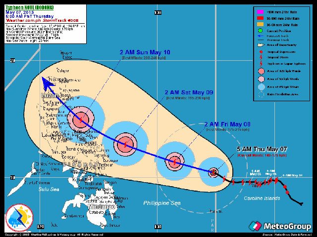
PAGASA weather forecaster Chris Perez said at the 9:30 am news briefing that Dodong is forecasted to make landfall in the Isabela-Cagayan area on Sunday, May 10.
Dodong is forecasted to move closer to the Bicol region and Samar provinces by Saturday morning, May 9.
‘Luzon should prepare’
Perez said Dodong may still “curve slightly upwards or downwards,” which means that “almost” the entire Luzon area should prepare for the typhoon.
“Hindi lang ang Isabela area ang dapat maghanda. Kung mapapansin natin, halos buong Luzon area kailangan maghanda sa mga darating na araw (Almost the entire Luzon area, and not just Isabela, should prepare in the coming days),” he said.
PAGASA’s forecast positions as of 11 am:
- 24 hours (Friday am, May 8): 575 km east of Borongan, Eastern Samar
- 48 hours (Saturday am, May 9): 220 km east of Virac, Catanduanes
- 72 hours (Sunday am, May 10): Vicinity of Isabela, Cagayan
- 96 hours (Monday am, May 11): Vicinity of Basco, Batanes
- 120 hours (Tuesday am, May 12): 495 km north northeast of Basco, Batanes
Updated tracks, including the forecast of US weather station Joint Typhoon Warning Center (JTWC), shows Dodong making landfall in Northern Luzon before veering north toward Taipei.
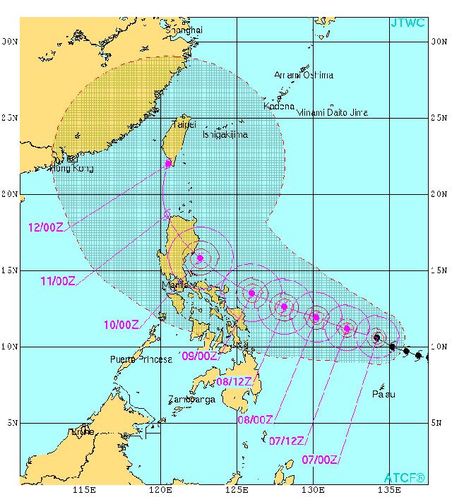
Earlier tracks showed it merely skirting the eastern side of the Philippine landmass.
But Dodong’s effects may be felt with the next 24-36 hours in eastern Visayas and Bicol region. PAGASA may raise warning signals in the next 12 hours.
Weather Philippines says those in Eastern Luzon, including the Bicol region, should also closely monitor Dodong.
The next Dodong update will be released at 11 pm. – Rappler.com
Add a comment
How does this make you feel?
There are no comments yet. Add your comment to start the conversation.