SUMMARY
This is AI generated summarization, which may have errors. For context, always refer to the full article.
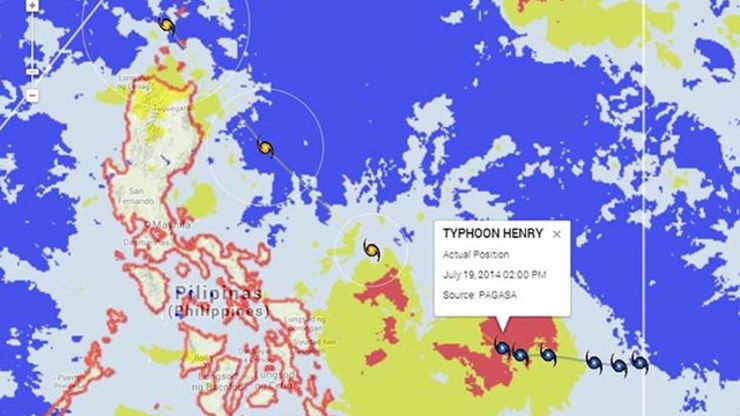
MANILA, Philippines (UPDATED) – Tropical storm Henry (international codename Matmo) has intensified into a typhoon Saturday, July 19, according to state weather bureau PAGASA.
As of 4 pm, the eye of Henry was located 530 kms east of Guiuan, Eastern Samar, having maximum sustained winds of 120 km/h near the center and gustiness of up to 150 km/h.
It is seen to move northwest at 19 km/h. Based on PAGASA’s current projections, the typhoon may not make landfall and just skirt or closely approach eastern Visayas, said PAGASA forecaster Jun Galang.
The typhoon will enhance the southwest monsoon or habagat, bringing rain to the western sections of the country, according to a weather bulletin by DOST-Project NOAH.
The typhoon is expected to be east of Catanduanes on Sunday afternoon, east of Isabela by Monday afternoon, and between the Babuyan and Batanes groups of islands by Tuesday afternoon based on PAGASA’s forecast track, the DOST-Project NOAH bulletin said.
Out mid-week
Henry is seen to leave the Philippine Area of Responsibility (PAR) by Wednesday or Thursday.
On Sunday, Eastern Visayas will experience cloudy skies with moderate to occasionally heavy rainshowers and thunderstorms.
Metro Manila, Bicol Region, Cagayan Valley, the provinces of Aurora and Quezon, the rest of the Visayas as well as Mindanao will have cloudy skies with light to moderate rainshowers and thunderstorms.
Meanwhile, the rest of the country will be partly cloudy to cloudy with isolated rainshowers and thunderstorms.
Coastal waters in the Visayas will be moderate to rough, as moderate to strong winds from the west to northwest will prevail.
In Luzon, winds coming from the southwest to west will be light to moderate, while winds from the west to northwest will prevail over Mindanao with slight to moderate seas.
| City | Forecast | Temperature Range |
|
| Metro Manila |  |
Cloudy skies with rainshowers and/or thunderstorms |
24°C-32°C |
| Tuguegarao | |
Cloudy skies with rainshowers and/or thunderstorms |
24°C-31°C |
| Laoag |  |
Partly cloudy to at times cloudy with rainshowers and/or thunderstorms |
25°C-30°C |
| Baguio | |
Partly cloudy to at times cloudy with rainshowers and/or thunderstorms |
15°C-21°C |
| Subic/Olongapo; Clark/Angeles | |
Partly cloudy to at times cloudy with rainshowers and/or thunderstorms |
23°C-31°C |
| Tagaytay | |
Partly cloudy to at times cloudy with rainshowers and/or thunderstorms |
23°C-29°C |
| Lipa | |
Partly cloudy to at times cloudy with rainshowers and/or thunderstorms |
24°C-31°C |
| Legazpi | |
Cloudy skies with rainshowers and/or thunderstorms |
25°C-29°C |
| Puerto Princesa | |
Partly cloudy to at times cloudy with rainshowers and/or thunderstorms |
24°C-31°C |
| Iloilo/Bacolod | |
Cloudy skies with rainshowers and/or thunderstorms |
24°C-30°C |
| Metro Cebu | |
Cloudy skies with rainshowers and/or thunderstorms |
24°C-30°C |
| Tacloban | |
Cloudy skies with rainshowers and/or thunderstorms |
24°C-29°C |
| Cagayan de Oro | |
Cloudy skies with rainshowers and/or thunderstorms |
24°C-30°C |
| Metro Davao | |
Cloudy skies with rainshowers and/or thunderstorms |
25°C-30°C |
| Zamboanga | |
Cloudy skies with rainshowers and/or thunderstorms |
24°C-31°C |
– Rappler.com
Add a comment
How does this make you feel?
There are no comments yet. Add your comment to start the conversation.