SUMMARY
This is AI generated summarization, which may have errors. For context, always refer to the full article.
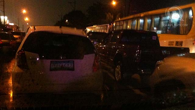
MANILA, Philippines – Confirmed: quick, heavy rain, plus rush hour traffic, equals a traffic nightmare. But will this be the metropolis’ new normal?
An analysis by the Manila Observatory showed the traffic gridlock in many of Metro Manila’s major roads last June 17 was a result of heavy rain unfortunately coinciding with the rush hour.
The study, released Tuesday, June 25, showed heavy rain fell mostly in parts of the metropolis’ south, caused by the southwest monsoon enhanced by tropical storm Emong (international codename Leepi).
“San Juan (city) recorded a total rainfall accumulation of 114.6 mm. Among the network of weather stations, West Rembo, Guadalupe (both in Makati), Navotas, Tayuman (Manila) and Payatas (Quezon City) also recorded the highest accumulated rainfall in the Metro,” the Observatory said.
San Juan recorded an average of up to 63 mm/h of rain; between 5 and 7 pm, the area got 105 mm of rain, the paper said.
The Metro Manila Development Authority (MMDA) puts 50 mm of hourly-accumulated rainfall as its threshold for flooding to occur in flood-prone areas, the paper said.
In comparison, the Observatory recorded 270 mm of rainfall in a span of 6 hours at the height of 2009’s tropical storm Ondoy (Ketsana). At its peak, the recorded rate ws 61 mm/h.
“Based on the results of the analysis, Metro Manila received the most rain from around 3:00 pm to 8:00 pm,” which coincided with the early evening rush hour, when people are traveling from work or school back to their homes.
Prior to 3 pm, there was “scant recorded rainfall,” which meant the ground, canals and waterways weren’t saturated with water. But when the rain suddenly fell in torrents, water accumulated quickly, causing floods, and could also have overwhelmed the city’s drainage system.
MMDA reports pointed out that EDSA and C-5 bore the brunt of the traffic jams that evening.
“This, along with other factors such as slope, obstructions or construction on the road, also may have contributed to the flash floods and caused several choke points along the flood-prone areas along EDSA and C-5,” it stated.
The study also showed a correspondence between the areas of greatest rainfall and flooded areas.
‘New normal’?
The study also raised a big question: will this be the new normal for the Philippine capital?
“[Many] Filipinos now realize, it doesn’t take a typhoon to create traffic chaos anymore,” the paper observed.
It said changing precipitation patters is creating “new normals” of heavy and intense rainfall, which means these extreme rainfall events will be more frequent.
“The rainy season is predicted to be much wetter than previously experienced, which poses real challenges to the public roads and infrastructure,” it said.
“Similar to Monday night, the heaviest rain can pour at peak travel times and many motorists may be trapped for hours in bad traffic as a result. Climate change threatens to make these situations worse because of the potential for more extreme rain,” the Observatory said.
Thus, it is important for Metro Manila, and for the rest of the country, to “engage in timely and efficient monitoring of the weather and road conditions,” as well as in giving accurate information.
The Observatory, a private, non-profit, Jesuit research institution, used rainfall data from Automated Weather Stations (AWS) installed throughout Metro Manila, as well as data from Metro Weather network, the MMDA, and the Makati City government. – KD Suarez/Rappler.com
Add a comment
How does this make you feel?
There are no comments yet. Add your comment to start the conversation.