SUMMARY
This is AI generated summarization, which may have errors. For context, always refer to the full article.
![[Ilonggo Notes] Heritage heaven: Exploring the southern coastal tip of Panay Island](https://www.rappler.com/tachyon/2022/07/Screen-Shot-2022-07-05-at-3.01.45-PM.png)
A few months ago, while doing research for a documentary on 500 years of Christianity in the Philippines, I had the opportunity to revisit several well-known churches dating back from the Spanish era, and discover some that were off-the-beaten track. All were within 90 kilometers of Iloilo City, accessible to public transport, making it doable as a day trip (or so I thought).
These gems are on the tip of the southwestern coastline of Panay Island, in the neighboring provinces of Iloilo and Antique. One is a UNESCO World Heritage site, the only one outside of Luzon. Almost all the churches in Panay were built by the Augustinian missionaries.
Why do they seem to be particularly clustered in this part of the coast of Panay? Well, I surmise that these areas had a number of strategic features – accessibility to trade and commerce, safe harbors, fertile, were more densely populated, and could also be protected from invaders, having lookout spots where one could see vintas, galleons, or other types of ships coming into the vicinity. Inland roads were often nonexistent then.

Historical myth has it that several datus from Borneo, escaping a cruel ruler, landed on the island tip’s shores – some say San Joaquin town in Iloilo, others say Hamtic in Antique – two to three centuries before the Spanish came, and the aborigines then in the area traded their land for gold and jewelry and moved upland into the interior, mountainous areas.
So off I went on a bus, to the farthest destination first, then worked my way back, aiming to see several of the noted churches along the way, or until I got “explorer fatigue.”
Antique Province: Hamtic and Anini-y
So straight off to Hamtic Plaza it was, via the well-traveled mountain route, alighting from the comfortable air-con bus after two hours. Conveniently there was a 7-11, so I popped in for a coffee and asked for directions to the first target for the morning: the cemetery-chapel. It was about a half kilometer away, partly hidden from the main road, and located at the center of the old Catholic cemetery.

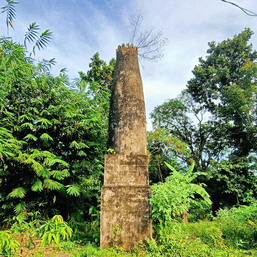
The road to the cemetery is narrow (well, it’s a one-way route, come to think of it) and lined with stately Neem trees. The cemetery is surrounded on three other sides by verdant rice fields. It was clear and sunny, an absolutely perfect day for pictures. For a campo-santo, the chapel seemed relatively big. It dates back to the late Spanish era. Other campo santos are tiny, domed, and shed-like, just big enough for the coffin, a priest, and maybe a dozen people. But this one was larger and shaped more like a church with belfry-like towers. Height is around 12 meters, of similar width, and around 20 meters long; it was made of blocks of coral rock and limestone, now darkened with dried moss. It has identical belfries, and a recessed area with a statue of the risen Lord, partly covered with foliage.
It appears to have three levels; the first has rows of tombstones, the second has sculpted Tuscan-style columns, and the third level has the belfries. The grilled doors were shut, but I peeped inside. The interior was smaller than I imagined; the side walls were quite thick, two meters each, and people were buried in the walls as well, thus taking most of the space from the outside. On the front of the church were two layers of headstones, eight on each side. They were uniformly similar yet small; sure enough, those interred there were either infants or small children, usually not over five years old. A few had names etched roughly on concrete, while one was painted a garish yellow, making it stand out like a sore thumb.
From the cemetery I walked back to the town’s plaza, with its arch sporting several huge black ants – those vicious biters called “hamtik” from which the town got its name.
I then boarded a jeepney bound for Anini-y, passing Guinsang-an (“Crossing”) where the road has a junction. One road leads back to the mountains and back to Iloilo; this is the main route for public transport. Anini-y was 20 kilometers away on the coastal route, and after 30 minutes, I got down at the plaza in front of the church.

The Anini-y church has an imposing air about it; it fills one side of the plaza, facing the road, unimpeded by trees or structures. Done in the Baroque style, it is dedicated to San Juan de Nepomuceno. It measures 48 meters in length and 13.5 meters in width, and was completed in 1879. When the Spaniards left, the church was abandoned and occupied by the Aglipayans, and in 1906 it was handled over to the Mill Hill Missionaries, a Catholic religious order from the UK.
The church was recently named a National Cultural Treasure, and a plaque from the NHI is on the front. The church pillars and the doorway arches are made of blocks of coral rock, but the external walls themselves are made from roughly cut coral stone bound together by stucco or some type of mortar. On the right side of the church you can see the stones all piled up, with no covering plaster. These rocks could have been gathered from the coast as there were coral-strewn white beaches less than 50 meters away. On the left side, however, the walls are plastered up so the layers of coral, with their intricate grooves and patterns, are no longer visible. The wall behind the altar is made up of layers and layers of the coral stones. The brown-colored main altar is a pleasant contrast to the whitened walls. There is a choir loft and a baptismal font.
In 2020, there was a plan to build a covered walkway from the road all the way to the church entrance, but heritage advocates protested since it would have blocked off a part of the church facade and the plans were scuttled. I soaked in the atmosphere a few more minutes, crossed over to the plaza, and took a bus bound for Iloilo.
Old Spanish-era churches and structures on Iloilo’s southern coast: San Joaquin to Oton

I managed to arrive at my next destination – San Joaquin, across the border from Antique, shortly after 1 pm. This town has two prominent historical cultural treasures – the church and the cemetery. The church is of the Baroque architectural style, completed in 1869, and was built on the foundation of an older church. Considered the “most militaristic” church in the country, its façade has sculpted scenes of the Battle of Tetuan (Morocco) that commemorate the victory of the Spanish over the Moors in 1859. The pained facial expressions are visible. The church is made from gleaming white coral rock, with tinges of pink and blue. Skilled masons from Spain and Mexico were brought in during its construction. It was declared a National Historical Landmark in 1963. I climbed up a stone stairway on the side up to the belfry, with is view of the town square and the sea.

All that walking was making me famished, so I had a break and took a quick turo-turo lunch at the public market. I then walked another half kilometer to the San Joaquin cemetery. It is of Neo-gothic style, built in 1892. The mortuary chapel in the center is known for its intricate Baroque style, made of coral rock and red bricks, with a domed roof. It sits on a small hill overlooking the sea, along the highway. From there I hopped on a jeepney to Miag-ao.

By then it was almost 3 pm and I needed a nap — so I tried out a pleasant garden restaurant in Miag-ao town. There I catnapped and had a coffee. Explorer fatigue had set in, so I decided to bide my time here and skip the remaining towns and churches in Miag-ao, Guimbal, and Tigbauan, having visited them already several times in the past.
The Sto. Tomas de Villanova Parish Church of Miag-ao is the best known and most photographed of all the churches of Panay, and is inscribed on UNESCO’s World Heritage list. It is of Baroque-Romanesque architectural style and completed in 1797. On its façade is a unique, folksy motif, with coconut, banana, papaya, and guava trees. The centerpiece is St. Christopher in rolled up pants, bending sideways and carrying the child Jesus on his shoulders. It has a commanding view of the mouth of the Miag-ao river, and served as a watchtower. Thick two-meter stone walls helped withstand earthquakes in the 1880s and 1940s.
Other major attractions in Miag-ao are Spanish-era stone bridges, such as the Taytay Boni. This stone bridge has been restored and is in use again for pedestrians and cyclists.

Tracing the route back to Iloilo City, next up was Guimbal town, with the Church of San Nicolas de Tolentino. The current church is the third iteration from 1774, following burning and damage brought about by pirates, World War II, and earthquakes. The outside walls are made of sandstone, called “igang,” quarried from Guimaras Island. The ochre color is distinctive. The church also served as a fortress.
Other heritage structures of note are the watch towers or “bantayan” along the coast of Guimbal, and the Spanish-era “Medici lions” on a small bridge along the national highway, a stone’s throw away from the church. A prominent political family has ruled Guimbal since the ’70s and their “rising sun” motif can be seen throughout the town center; all the fences and gates in town sport this. It gives the impression that this is all one big hacienda!
Tigbauan, the next town, is seven kilometers from Guimbal. The present church is of Mexican architectural style and was built in 1867, together with the convent. It has lavish, Rococo-style stone ornamentation on its central façade and encompassing the main entrance. This makes it stand out from the rest of the plain plastered walls. The churchyard was the site of the first Jesuit boarding school for boys in the Philippines, established by Pedro Chirino in the 1580s. In 1994 mosaics were installed inside the church, making several heritage advocates scratch their heads in puzzlement.
Down to Oton, the last stop and first town outside of Iloilo City. This settlement has existed before the coming of the Malays. It had a grand basilica but it was devastated by an earthquake in 1948 and was never restored. A new church was built beside it. What remains now of the old basilica are blocks of rubble that were creatively re-designed into an open-air grotto with the Stations of the Cross. A huge lunok (ficus) tree provides the shade.
You can enjoy a stroll in the plaza across it, which is one of the nicest in the province, with an amphitheater and a bas relief sculpture portraying the town’s history. Hop on another jeepney and in 20 minutes you’re back in the heart of Iloilo City. – Rappler.com
Explore new cities and tourist spots using this Agoda voucher code.
Add a comment
How does this make you feel?


There are no comments yet. Add your comment to start the conversation.