SUMMARY
This is AI generated summarization, which may have errors. For context, always refer to the full article.
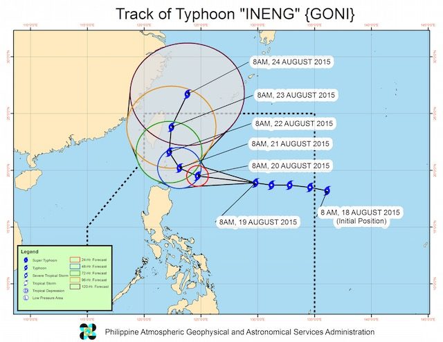
MANILA, Philippines – The National Disaster Risk Reduction and Management (NDRRMC) placed its national operation center and its units in 4 regions on red alert starting 12 noon Wednesday, August 19, as Typhoon Ineng (Goni) continued its westward movement, moving closer towards extreme northern Luzon. (READ: Typhoon Ineng: Batanes, Cagayan under Signal #2)
Allan Tabel, Department of the Interior and Local Government’s Disaster and Information Coordinating Center (DILG-CODIX) chief, said this means all agencies under NDRRMC and its offices in Regions 1, 2, 3, and the Cordillera Administrative Region (CAR) must report to their headquarters 24/7.
Senior officers like Tabel are assigned to their respective operation centers to monitor the typhoon. At the national level, the NDRRMC is regularly conducting a pre-disaster risk assessment (PDRA).
The PDRA is a tool that identifies possible risks and impacts of particular hazards in specific areas over a particular period of time.
What to expect
Using data from state weather bureau PAGASA, the NDRRMC, in its Wednesday morning PDRA report, indicated what the affected regions should anticipate:
- The typhoon is expected to directly affect extreme northern Luzon
- It will enhance Southwest Monsoon (Habagat) and will bring light to moderate rains over Visayas and Mindanao
- It will bring moderate to heavy rains over northern and western Luzon beginning Thursday evening, August 20
- The Eastern Luzon seaboard will be rough to very rough and dangerous to all sea vessels
- The typhoon is expected to exit the Philippine Area of Responsibility on Sunday, August 23
Habagat
Tabel stressed that local government units and the public “should not only look at the typhoon but also the Southwest Monsoon (Habagat).”
As of Wednesday noon, the Project NOAH hazard impact analysis for Typhoon Ineng indicated that at least 64 provinces may experience 100 mm of rain due to the Habagat. This might trigger landslides and floods, according to Project NOAH.
On Wednesday, DILG-CODIX and the League of Municipalities have started warning at least 100 towns to prepare for the risks posed by the typhoon and the Habagat, Tabel said.
Areas expected to be affected by at least 100 mm per hour accumulated rainfall are given 3 to 12 hours lead time to prepare, Tabel added.
PAGASA issued a new bulletin on Ineng at 5 pm, Wednesday (READ: Stormy weather for Northern Luzon on Thursday). – Rappler.com
Check if your mayors are conducting preparedness activities that LGUs should be enforcing in areas expected to be affected by Typhoon Ineng. Tell us how prepared your LGUs are through email (move.ph@rappler.com) or Twitter (@moveph).
Stay alert and ready with the latest weather and disaster information through Project Agos.
Add a comment
How does this make you feel?
There are no comments yet. Add your comment to start the conversation.