SUMMARY
This is AI generated summarization, which may have errors. For context, always refer to the full article.
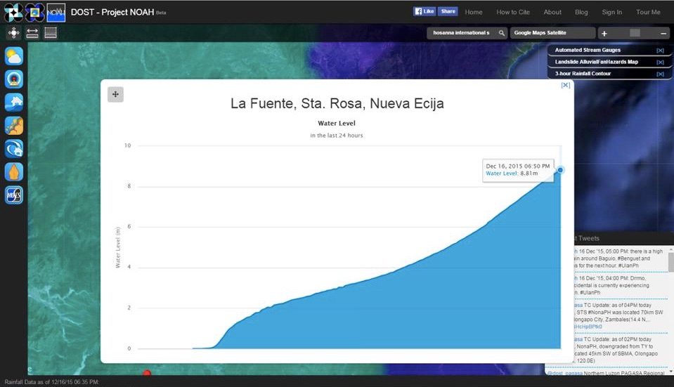
MANILA, Philippines (UPDATED) – Project Noah warned residents in flood-prone areas in Central Luzon to be alert as the water level of the Pampanga River continued to rise, Wednesday night, December 16.
The river’s water level in La Fuente, Nueva Ecija reached 9.62 meters, and is still rising, as of 9:40 pm, Project Noah executive director Mahar Lagmay said, citing latest data from the government’s platform that helps identify disaster hazards.
Many towns in Central Luzon were submerged in flood waters when Typhoon Lando (international name Koppu) hit the Philippines in October.
Evacuate now
The warning means that affected residents should be evacuated from the areas at risk as soon as possible, according to the Department of the Interior and Local Government (DILG).
“LGUs should immediately conduct preeemprive evacuation of all residents in all communities along the river basin and all low-lying areas,” Allan Tabell, chief of the DILG’s Central Office Disaster Information Coordinating Center (CODIX), stressed.
See the affected areas in the map below.
These barangays in Bulacan and Pampanga were some of the most heavily affected by floods during Typhoon #LandoPH. These…
Posted by DOST – Project NOAH on Wednesday, 16 December 2015
“These barangays in Bulacan and Pampanga were some of the most heavily affected by floods during Typhoon #LandoPH. These same barangays are now at risk from a flood event due to Typhoon #NonaPH. Please be advised and stay safe,” Project Noah warned in an advisory Wednesday night.
Meanwhile, state weather bureau PAGASA said Tropical Depression Onyok entered the Philippine Area of Responsibility at 1:45 pm, December 16, joining Severe Tropical Storm Nona.
In its bulletin issued 5:30 pm on Wednesday, PAGASA said Onyok was last spotted 860 kilometers east of Mati City, Davao Oriental, moving west northwest at 20 kilometers per hour. – Rappler.com
You can help report critical information such as flooded areas, damaged roads, or people in need of rescue by reporting your location and the situation on the Agos Disaster Alert Map.
Add a comment
How does this make you feel?
There are no comments yet. Add your comment to start the conversation.