SUMMARY
This is AI generated summarization, which may have errors. For context, always refer to the full article.

MANILA, Philippines – Tropical Depression Domeng (international name Peipah) has changed course and is now moving slowly northwest instead of the earlier west northwest direction, according to state weather bureau PAGASA.
The storm was originally forecast to traverse the Surigao provinces, southern Cebu, Bohol, Negros island, and Coron in Palawan. But according to PAGASA’s 11am Tuesday, April 8, update, the tropical depression will not make landfall in th next 3 days. (READ: Quick links: Preparing yourself, your family and home for disasters)
The maps below show which areas along Domeng’s track are susceptible to rain-induced landslides and floods. (READ: #DomengPH: Help map critical reports)
Storm surges
The Department of Science and Technology (DOST) and Project NOAH on Monday, April 7, issued storm surge warnings for coastal areas in Maguindanao, Negros Occidental, Cebu, Negros Oriental, Surigao del Norte, and Surigao del Sur.
Earlier reports said the sea level would rise to a total height of two (2) meters, with the storm surge and the high tide. But Project Noah Executive Director Mahar Lagmay clarified that this would not be the case.
“The high tide level is still at sea level. Only the storm surge will spill over land. The storm surge will not reach 2 meters. Total water levels above the normal will only be the predicted height of the storm surge,” Lagmay told Rappler on April 7.
Government scientists adjusted the forecast model because Domeng was downgraded from a tropical storm to a tropical depression. (MUST READ: Storm Surge 101: Are you at risk? Are you prepared for it?)
The list of localities Project NOAH produced is a model run with 4,884 stations from specified localities with storm surge. A tide station is used to measure water levels, and provide meteorological and current observations.
Flood Hazard
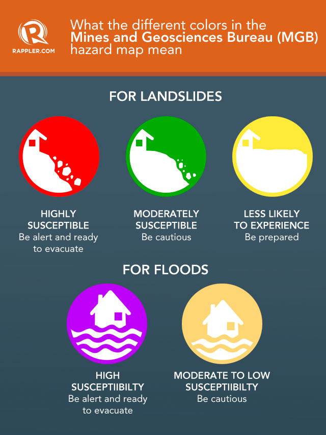
The map below shows which areas along Domeng’s track is susceptible to floods and flashfloods. It is based on shapefiles of hazard maps produced by the Mines and Geosciences Bureau (MGB) – the government agency responsible for the management and development of the country’s mineral resources and lands.
According to MGB Lands Geological Surgery Division OIC Lilian Rollan, the different colors show different levels of danger. People living in different colored areas also need different levels of preparation.
Rollan explained that:
- Violet areas have high susceptibility to floods. They are usually near bodies of water or prone to flashfloods. According to Rollan, residents in these areas must always be ready to evacuate.
- Light yellow areas have moderate to low susceptibility to floods. These areas, however, are still vulnerable to “dangerous debris flow.”
Rain-induced landslide hazard
The map on the MGB’s website also indicates areas prone to rain-induced landslides with 3 colors – red, green, yellow.
- Red areas are highly susceptible to landslides. If a storm passes through a red area, people need to be alert. When water saturates the area, a landslide will likely occur. According to Rollan, people living in red areas should always be ready to evacuate. The longer the rainfall, the more vulnerable the red areas become. Those in red areas are mountains with steep slopes, fractures, and structurally weak rock formations with a history of landslides.
- Green areas are moderately susceptible to landslides. People living here, however, still need to be cautious. These are usually mountains and rock formations with moderate slopes.
- Yellow areas are less likely to experience landslides. Landslide debris, however, might still affect the areas as they might possibly become an accumulation zone.
Changing environment
Rollan said the maps are prone to changes as “our environment is not static” – areas identified with low susceptibility can always progress to high susceptibility.
“People should always listen to warnings. MGB always provides advisories to local government units so the map can always be updated,” Rollan added.
The MGB website also gives the following disclaimer:
“The underlying data in this application was compiled from different sources, including Mines and Geosciences Bureau (MGB), and were obtained in different scales, thus accuracy of the geographic features and attributes cannot be guaranteed. Furthermore, the maps included in this application may be subjected to change and/or updates and for visual presentation only and cannot be used for other purposes.”
The resolution of the MGB geohazard map that is currently published on its website is at a scale of 1:50,000.
The bureau is currently working on a higher resolution map at a scale of 1:10,000. They are also creating a map for sinkhole susceptibility. – Rappler.com
Add a comment
How does this make you feel?
There are no comments yet. Add your comment to start the conversation.