SUMMARY
This is AI generated summarization, which may have errors. For context, always refer to the full article.
SAINT BERNARD, Southern Leyte – First came the rains. Then came the mud and the cries of panic. Then, there was silence.
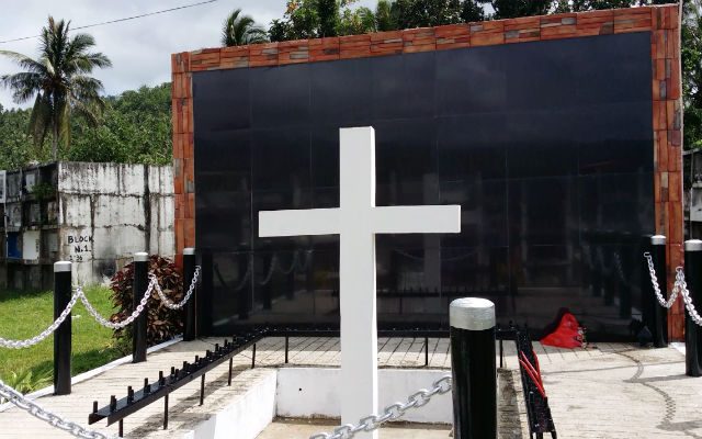
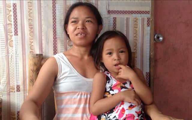
It has been 9 years since that fateful day on February 17, 2006, but 24 year-old Perla Bautista still remembers clearly the tragedy that changed her life. That day, an entire section of a mountain buried half of her family along with almost 1,500 people in Barangay Guinsaugon in Saint Bernard town, Southern Leyte.
Perla was 15 years old when she lost her parents and 4 siblings to what is now known as the Guinsaugon tragedy. She was studying at the Tambis National High School when they heard a loud sound and cries for help from the nearby village. Perla’s school, located a few hundred meters from the landslide site, was spared.
“It had been raining for 2 weeks but that day, the sun came up. We thought it would be a beautiful day,” Bautista recalled.
According to post-disaster assessment reports, the landslide was triggered by what would seem like a fairly insignificant earthquake – a magnitude 2.6. What made the earthquake so fatal was that it was preceded by 10 days of continuous rain, and it happened in an area that was vulnerable to landslides to begin with.
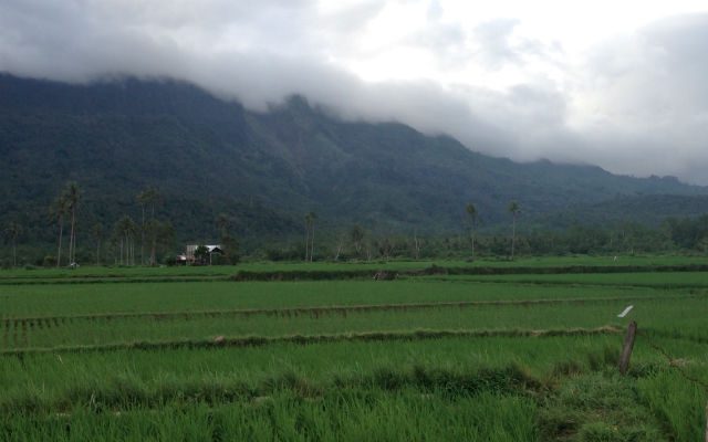
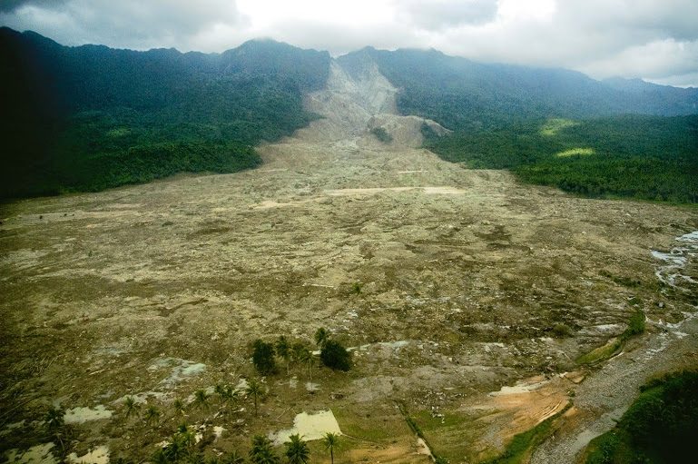
Experts now say it is this confluence of factors that caused 1.2 billion cubic meters of mud and boulders to come sliding down the slopes of Mt. Can-abag that Friday morning, 9 years ago. Moments after the landslide, what was a thriving community surrounded by verdant ricefields was covered in 300 hectares of thick, impenetrable mud.
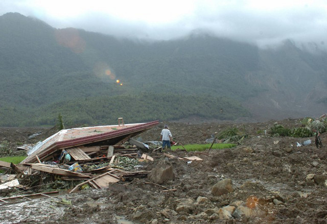
“There was mud everywhere. Boulders were spread across the fields and the residential areas. The people were saying that there was no more Guinsaugon. We were just crying,” Bautista said.
The tragedy left many orphans like Bautista and her 6 other siblings. “We did not know what to do then since we lost our parents. Our relatives wanted to take us far away but we didn’t want to leave this place. Our family is buried here,” she said.
Buried in mud
Mitzi Adobas remembered the panic and the weeks of sleepless nights that followed after the tragedy. She was a part-time disaster responder for the Southern Leyte province working in the treasurer’s office of Saint Bernard.
Authorities and responders from the military came in almost immediately. Rescue groups from other countries, including the United States military, also joined in the rescue efforts.
But chances of survival in a mudslide were very slim, to begin with, according to experts. Where it settles, mud seals potential sources of air leaving those trapped under the buried structures with very little air supply.
It did not help that in 2006, most municipalities like Saint Bernard had no organized disaster risk reduction and management office (DRRMO) and rescue teams. The town only had part-time disaster responders. It was only in 2010, when RA 10121 was passed, that local government units (LGUs) started organizing their local responders. (READ: Disaster management chief says agency needs overhaul)
“There were only 3 of us rescuers here. We knew we couldn’t respond to a disaster that big so we headed to the adjacent communities and forced them to evacuate. Many communities were in that valley and we were afraid there will be another landslide,” Adobas, who is now Saint Bernard’s disaster management chief, said. Adobas and her team went to the landslide site after evacuating the nearby communities.
Challenges to rebuilding
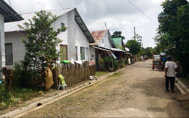
Nine years after the tragedy, Saint Bernard still grapples with the challenges associated with rebuilding. Established as a municipality in 1954 by then President Ramon Magsaysay, Saint Bernard is prone to practically every natural hazard, maps provided by the Philippine Institute of Volcanology and Seismology (PHIVOLCS) and the Mines and Geosciences Bureau (MGB) show.
The town’s coastal areas directly face the Pacific Ocean where typhoons regularly pass. Rocks in the mountains that surround this town were shattered millions of years ago when the Philippine fault system sliced through them. All these make the town vulnerable to storm surges, flooding, earthquake-induced landslides, ground shaking, tsunamis and liquefaction.
“We have many hazards here. Only the town center is quite safe. So this is where we bring those who need to be evacuated every time there’s a major disaster,” Adobas said.
Given these hazards, determining the relocation sites for the survivors of the 2006 landslide and the other hazard-prone communities was the first major challenge for the local government. “If you check the maps, everything is red. No place is liveable. So we brought the maps from PHIVOLCS and the MGB to the communities and let them identify the specific safe zones in their areas,” Adobas added.
If the hazards maps are to be followed, 26 of the 30 barangays in Saint Bernard would have to be either fully or partially relocated. “We recently learned that we’re also prone to volcanic eruptions because of Mt. Cabalian,” Adobas said.

The maps were required by the donor agencies before aid could be released. Before releasing resources for building new homes for those affected, donor agencies like the Red Cross, Gawad Kalinga, the Japan International Cooperation Agency (JICA), and other international groups also required Saint Bernard town to develop a land use plan. Thus, with the help of the MGB, the town crafted one.
In 2008, two years after the tragedy, Saint Bernard was awarded the Gawad Kalasag – a recognition of the best DRRM efforts in the country – for having thebest Contingency Plan and DRRM Program.
Yet a study from the Technical University of Munich found that though Saint Bernard’s Comprehensive Land Use Plan (CLUP) had clear goals and doable strategies, implementation was slow. Disaster risk reduction (DRR) concepts were also not integrated into the CLUP.
What happened to the aid money?
Almost a decade after the tragedy, much remains to be done.
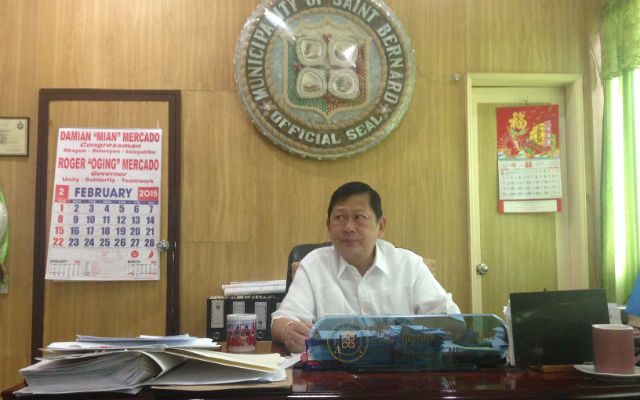
It did not help that the task of rehabilitating the town has been passed on several times due to local leadership changes. When the landslide happened in 2006, Saint Bernard was under the leadership of Mayor Maria Lim. From 2007 to 2013, the task of rehabilitating the town fell on the shoulders of Mayor Rico Rentuza. Incumbent Saint Bernard Mayor Napoleon Cuaton, a 1-star police general, assumed office in 2013 and is serving his first term.
Soon after the tragedy, rescue and relief assistance from around the world rushed to aid Saint Bernard after the landslide, raising some P29 million for financial aid. It was sustained by international and local non-governmental organizations (NGOs).
Cuaton told Rappler that the first thing he checked when he assumed office in 2013 were the rehabilitation programs for the Guinsaugon landslide. He complains that the aid that came in was not used strategically. Instead of being used to fund livelihood programs, the local government just handed funds out to the people.
“The past administration just gave and gave to the people,” Cuaton noted. There were no clear directions in how the aid were used, he said. “So when the donor agencies got tired of giving, the people were left with nothing.”
With donor funds gone, the town now has to rely on its own meager resources to move forward on relocation and development plans. It is a tall order for in 2010, Saint Bernard’s budget is only P49.89 million. This amount includes the P43.3 million the town gets from the national government as its share in the internal revenue allotment.
That same year, Saint Bernard only earned P1.4 million from local taxes.
Saint Bernard had requested funds from Office of Civil Defense and the Department of Public Works and Highways to build dikes and other hazard mitigating infrastructures for its communities. The proposal has been pending for 3 years.
“Our second biggest barangay is in danger of flash floods so we’re really afraid. We badly need structural mitigations. We already did tree and bamboo plantings but they’re just band-aid solutions,” Adobas said.
“Our calamity funds are only 5% (of total budget). Some 70% of that 5% should be used in mitigation. How about the small municipalities, where will they get their money? We always talk about climate change but we don’t invest on mitigating it,” Cuaton added.
Livelihood concerns
Sustainable livelihood remains a constant obstacle to Saint Bernard and the survivors of the 2006 landslide. Sources of livelihood in the area are farming, fishing, coconut planting, and growing crops like abaca.
“When they identified the relocation sites, they didn’t take livelihood in consideration so the people there had no means of living,” the mayor said.
Various government agencies gave livelihood opportunities to the relocated survivors but not all worked out. The Philippine Coconut Authority wanted to innovate the coconut products produced in the town but the plans did not push through. The Department of Science and Technology (DOST) taught the survivors how to make noodles as a means of livelihood but the survivors did not take to noodle production.
“I talked to the people and asked them how we can work together. ‘What is your interest?’ I asked them. They said they wanted to farm because that’s the only thing they know,” Cuaton said.
Thus, the local government allowed the survivors to use the landslide site for farming and raising fish in ponds on the condition that workers are no longer allowed to stay in old Guinsaugon overnight.
“They farm there during the day and go back to their new homes at night. They can’t live there but they’re allowed to work there,” Cuaton added.
On guard
Despite the financial challenges, Saint Bernard’s DRRMO was able to purchase rescue equipment like rubber boats and ambulances. Aside from the provincial office, it’s the only municipal disaster management office in the province that maintains a 24-hour operation.
The town also invested in installing extensometers (devices that determine if cracks are moving) in different communities. “We told them to report if they see any movements in the cracks in their infrastructure. We’re not yet done because there are so many cracks,” Adobas said. The communities also regularly cleans its canals and dredges its waterways to lessen flooding.
Nine years after the tragic landslide, Cuaton said Saint Bernard is back to normalcy.
Cuaton now plans to develop the landslide into an eco-park to attract more tourists to the town. “The Department of Tourism and the provincial government already allowed the area to be developed. When tourists start visiting the area, we’ll be able to give more income to the community,” he added.
Landslide survivors like Bautista have also moved on in their lives. Bautista has 2 children now. Her husband is one of the farmers who till the farm lands in old Guinsaugon.
When she goes to the landslide site, Bautista said she talks to members of her family who perished in the mud. “It’s a scar that will never fully heal, I guess. We, survivors, get fragile when we talk about it.”
She also makes it a point to tell her children about the tragedy that killed her parents and siblings. “I had to tell them what happened so the next generation will not forget.”
Watch this video report on the survivors of Guinsaugon.
– Rappler.com
Project Agos is a collaborative platform that combines top-down government action with bottom-up civic engagement to help communities learn about climate change adaptation and disaster risk reduction. Project Agos harnesses technology and social media to ensure critical information flows to those who need it before, during, and after a disaster.
Project Agos is supported by the Australian Government.
Add a comment
How does this make you feel?
There are no comments yet. Add your comment to start the conversation.