SUMMARY
This is AI generated summarization, which may have errors. For context, always refer to the full article.

MANILA, Philippines – By now, a number of us would have come across accounts of a terrible typhoon that swept central Philippines 116 years and barely a month to the day of Yolanda’s (Haiyan’s) destructive visit.
Until I scanned quickly through the scientific study published by Fr. Jose Algue, S.J. of the Observatorio de Manila, and entitled “El Baguio de Samar y Leyte, 12-13 de Octubre 1897,” I did not realize the full significance of the storm surge that devastated practically the same region that Yolanda did.
Fr. Algue and his team from the Observatory, having received in Manila the report from the Capitan del Puerto de Tacloban only on October 20 of the events of October 12 and 13, 1897, decided to conduct an ocular inspection of the affected areas to verify details of, among others, “grandes movimientos” in the seas, with extraordinary storm surges and inundation of coasts, total destruction of towns and even disappearance of islands and deformation of coasts.
Similarities
The typhoon of October 1897 had similarities with Yolanda in terms of its path: it landed very near Guiuan in Samar, proceeded to Tanauan, Palo and Tacloban in Leyte, struck northern Cebu and northern Panay (then the province of Capiz which included the present-day province of Aklan) and exited just south of Mindoro island. (See general map)
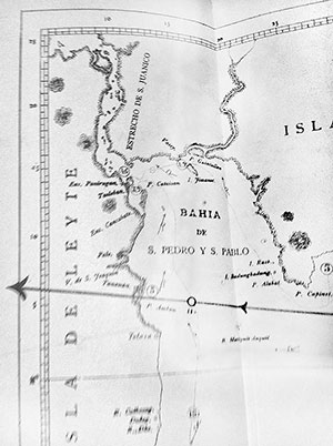 The similarity does not end there: a storm surge or “ola de huracan” laid low everything in its path. Perhaps comparable to Yolanda, the height of the storm surge reached more than 7 meters in some places. In Tanauan, 5 meters; in the Tacloban peninsula where the airport now stands at around 3.9 meters and on the other side of Tacloban close to San Juanico Straight, 4.5 meters.
In Vasey (now Basey) Samar, it was estimated at 4.9 meters, and between Marabut and Lawa-an in what is now Eastern Samar, at 5 meters. Hernani on the eastern Samar coast experienced a storm surge of 7.3 meters. (See detailed maps of Leyte and Samar areas).
The theory surrounding storm surges is extensively discussed in the work. Of note is the observation that “los baguios” are accompanied by a considerable rise in sea levels called “ola del huracan” and traced to the same cause that results in a significant lowering of barometric readings.
It admits that the name “Ola del huracan” is not entirely accurate in describing the nature and characteristics of that mountain or mass of water (“montaña o masa de agua”) which accompanies a storm’s vortex, but it is a term which has been used by Spanish mariners since ancient times.
An even more extensive discussion of the different meteorological phenomena of the typhoon as it passed through the archipelago is included in the Algue work. The barometric readings from various parts of the country are recorded and explained, accompanied by pictures and sketches of the extent of the devastation.
The number of fatalities are summarized as follows: In Samar—Quinapundan 12, Hernani 166, Salcedo 44, Mercedes 5, Guiuan 94, Balangiga 27, Vasey 500 (approximate). In Leyte: Tacloban 200 (probably more than less), Visita de San Joaquin 11, and the rest of Leyte 240 (approximate). Approximate total for both islands: 1299. Just for comparison, at that time, Hernani had 4000 inhabitants and Palo in Leyte had a total population of around 14,000.
The pictures speak for themselves. The communities and churches of Samar and Leyte, including Guiuan, Tacloban and Palo were destroyed in 1897.
Hope after devastation
For me, their most eloquent unspoken message for us today is one of hope: these communities did live again; and they will once more.
In rebuilding and reconstruction, however, it is best to plan with the safety of the population and critical infrastructure foremost in mind.
The observations of the Capitan del Puerto de Tacloban who almost lost his life in 1897 are worthy: The ola del huracan entered Tacloban at the opening of the bay of San Pedro and San Pablo, converged with the waters of San Juanico Strait and of the Port.
Aggravating the elevated waters were the surrounding mountains found on all sides except for the part where the town is located, which is not more than a tongue of low-lying land. Since this was the only available exit for the waters, understandably they attained such considerable height and theinundation was the principal cause of the fatalities.
The October 1897 typhoon was considered, based on the energy of its internal or cyclonic movement, among the most violent that traversed the Philippine archipelago. As indicated by barometric readings, it was 5 times greater than the famous typhoon of October 1882 which tracked the southern part of Luzon. Based on its accompanying storm surge and the havoc caused, it was considered as entirely extraordinary.
Until Yolanda, that is.
With the growing frequency and easing intensity of extreme events, we need to increase the resiliency of our people and communities through deliberate planning and action in the course of rehabilitation and rebuilding.
History in Samar and Leyte provides us lessons. Together, we must act intelligently on them. – Rappler.com
(The author is a former energy secretary. The accompanying pictures from “El Baguio de Samar y Leyte, 12-13 de Octubre de 1897” by P. Jose Algue, S.J. were published by the Observatorio de Manila, Dirigido por los Padres de la Compañia de Jesus. Foto-tipografia de J. Marty. Manila: 1898. From the Emilia A. Lotilla Book Collection.)
Add a comment
How does this make you feel?
There are no comments yet. Add your comment to start the conversation.