SUMMARY
This is AI generated summarization, which may have errors. For context, always refer to the full article.
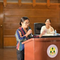
To help authorities make data-driven decisions in disaster response, the Philippine Institute of Volcanology and Seismology (Phivolcs) launched on Thursday, July 16, a new application that showed the possible impact of disasters to communities.
Called GeoMapperPH, Phivolcs’ new web and mobile application was specifically designed to collect and update natural hazards, exposure, vulnerability, and coping capacity data. Phivolcs said the application aimed to empower authorities to make “comprehensive, appropriate, and well-informed decisions and actions for disaster management.”
“Kailangan natin ito upang malaman natin bago pa man magkaroon ng trahedya yung mga posibleng maapektuhan. We want also to know immediately the effect of these various natural disasters and health emergencies…Upang magkaroon tayo ng basehan for appropriate decision-making for disaster preparedness response and even for ordinary planning and monitoring of projects,” said Phivolcs Director Renato Solidum Jr.
(We need this so we would know who would possibly be affected before tragedies happen. We want also to know immediately the effect of these various natural disasters and health emergencies… So we will have basis for appropriate decision-making for disaster preparedness response and even for ordinary planning and monitoring of projects.)
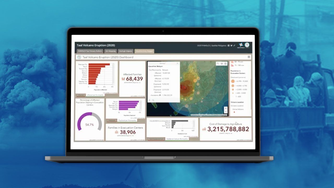
Through the application, national agencies and local government units can set up real-time dashboards and do data visualization using its situation data mapper.
Deriving its information from government agencies like the National Disaster Risk Reduction and Management Council, the mapper can compile data relating to disasters that have struck a given area throughout a specific period in one platform.
This would allow authorities to see a summary report of the impact of these disasters, including the number of casualties, affected individuals, families in evacuation centers, damaged buildings, cost of assistance, and total cost of damage to agriculture and infrastructure among others in easily understandable charts.
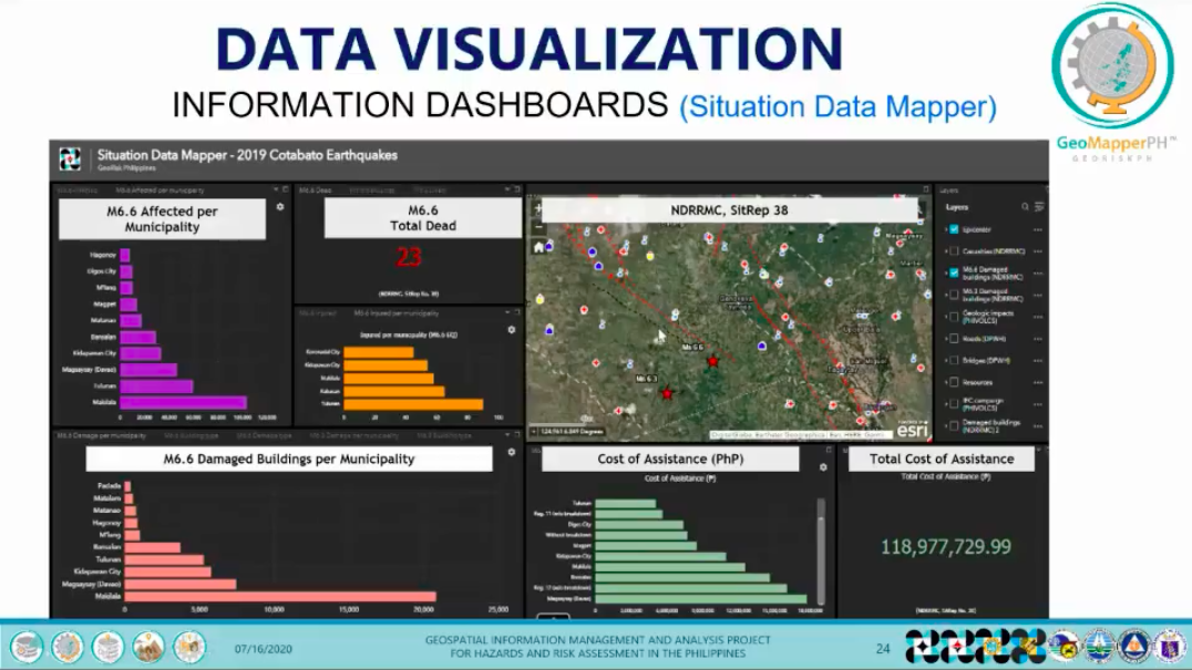
In its dashboard, the application’s situation data mapper can also monitor affected elements that are at risk during the passage of a typhoon. It can even show possible affected schools in its path according to data from the Department of Education.
The data from different national agencies and local government units can be collated in one platform to help authorities better understand the hazards and the possible impact of disasters.
“After a disaster, we can also use the situation data mapper for awareness [of] affected population, affected institutions…These are tools and these are platforms, and you can use this. We can build on each other’s strength,” added Mabelline Cahulogan, the project leader of GeoRiskPH.
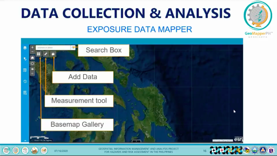
Aside from visualizing data, the application can also be used by authorities to help map school buildings, health facility buildings, lot areas, hazard and exposure information, and situation reports of incidents for accurate impact and risk assessments.
The application can be used offline and can also be downloaded on mobile devices through the Google Play Store. Information and photos from field surveys, for instance, can be inputted into the application to be synced to the database once online.
“With this innovation, we can really optimize the data that we have,” said Cahulogan. “Especially this time of pandemic, you can still use this so long as you have internet connection at home.”
‘Not enough to just know the hazards’
The launch was timely as it marked the 30th anniversary of the 1990 Luzon earthquake. Recorded at magnitude 7.8, the earthquake was one of the most destructive to hit the island after it left a staggering US$369-million worth of damage in its wake and an estimated 2,412 people dead.
Solidum pointed how large-scale disasters like the 1990 Luzon earthquake and the current coronavirus pandemic can severely impact the economy, business and government operations, and people’s way of life.
One way to adequately respond and prepare for these large-scale disasters, according to Solidum, is to help local government units and national agencies understand the impact of these disasters and the existing hazards that lie in their area using data.
“It is not enough to know the hazards. We need to know which communities, ilan ang mga tao, aling mga businesses [will be affected]. Ano ang operations and vulnerabilities na dapat natin i-mapa upang malaman natin ano ang magiging epekto ng mga lindol at iba pang mga natural and even health-related events like this COVID-19. We need to capture all of this information, nationwide, in a consistent data format at madaling gawin,” said Solidum.
(It is not enough to know the hazards. We need to know which communities, and how many people and businesses [will be affected]. What are the operations and vulnerabilities that we have to map so we know what will be the effects of earthquakes and even health-related events like this COVID-19 pandemic. We need to capture all of this information nationwide in a consistent data format that’s easy to do.)
GeoMapperPH is so far only available for use by national agencies and local government units to ensure data entering the system are vetted and correct.
However, 2 other applications of GeoRiskPH namely HazardHunterPH and GeoAnalyticsPH are available to the public to generate initial hazard assessments in your selected location, and perform analysis and visualization of those at risk to natural hazards. These have been updated as well to be more user-friendly.

Hoping the application would reach more authorities, Cahulogan said their team hoped that the use of GeoMapperPH would eventually be institutionalized among local government units and national agencies.
“GeoMapper is a tool for data collection, analysis, access and visualization. If this would be institutionalized in the government, we can use this to develop the national exposure database, which is very crucial for hazard assessment, risk assessment, impact assessment and even resource mapping for decision-making, as well as for developing science-based policies,” added Cahulogan.
Since the 1990 Luzon earthquake, the Department of Science and Technology-Phivolcs has ramped up disaster risk reduction efforts. Aside from the applications under the GeoRiskPH platform, Phivolcs has expanded its seismic stations from 12 to 104 in a bid to enhance seismic monitoring capability for faster and more accurate delivery of earthquake information. – Rappler.com
Add a comment
How does this make you feel?
There are no comments yet. Add your comment to start the conversation.