SUMMARY
This is AI generated summarization, which may have errors. For context, always refer to the full article.

MANILA, Philippines – Rainfall during the past 22 hours has surpassed the rainfall recorded during tropical storm Ondoy in 2009.
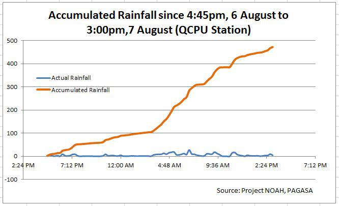
From 4:45 pm on Monday, August 6, to 3 pm Tuesday, August 7, the rain gauge at the Quezon City Polytechnic University recorded an accumulated 472 millimeters of rain, according to Dr Mahar Lagmay, executive director of the National Operational Assessment of Hazards (NOAH).
Lagmay’s data is from NOAH and the state weather bureau Pagasa.

This is higher compared to the 455 mm, 24-hour accumulated rainfall during tropical storm Ondoy (international codename Ketsana) back in Sept 26, 2009, measured at the Pagasa Science Garden in Quezon City.
In an interview on ANC, the ABS-CBN News Channel, Lagmay said the data must be put into perspective.
“The accumulated rainfall, although it’s higher now, is different from Ondoy because the Ondoy’s accumulated rainfall, much of that was delivered over a shorter span of time, within 6 hours … so the intensity of that rainfall then during Ondoy was higher than the intensity delivered during this rainfall.”
An enhanced southwest monsoon is causing the non-stop rain pouring over large parts of Luzon, including Metro Manila, Pagasa said.
Even as the tropical storm Haikui is well out of the Philippine Area of Responsibility, it continues to affect the southwest monsoon, which is bringing rain to larger parts of Luzon.
The southwest monsoon will continue to bring occasional to frequent rains over Luzon, Pagasa said in its 11 am weather advisory on Tuesday, August 7.
Haikui is 300 kilometers northeast of Taiwan, and will continue to enhance the monsoon.
Continuing rain
Rain will become moderate to heavy over the following areas from Tuesday until Wednesday, August 8, in the following areas:
- Ilocos Norte
- Ilocos Sur
- La Union
- Pangasinan
- Tarlac
- Zambales
- Bataan
- Pampanga
- Bulacan
- Rizal
- Cavite
- Laguna
- Batangas
- National Capital Region
Pagasa said a “gradual improvement” in the weather will occur by Thursday.
These areas are advised to be on the lookout for landslides and flashfloods, especially in mountainous and flood-prone areas.
Meanwhile, heavy rainfall is still expected over Metro Manila, as it remains under the Red Warning signal raised by Pagasa earlier in the day.
In its 3:30 pm Red Warning bulletin, Pagasa said heavy to intense rainfall (10-30 mm/h) is expected over Metro Manila in the next 3 hours.
The rain will be occasionally torrential (more than 30 mm/h), the weather bureau added.
Heavy to intense rainfall (7.5-28 mm/hr) was observed over the metropolis between 12nn and 3 pm. – Rappler.com
Add a comment
How does this make you feel?
There are no comments yet. Add your comment to start the conversation.