SUMMARY
This is AI generated summarization, which may have errors. For context, always refer to the full article.
CAGAYAN DE ORO CITY, Philippines – Is there a looming battle over the use of the old Lumbia airport?
The national government is not the only one eyeing the old airport, reportedly for use by the US military under the Enhanced Defense Cooperation Agreement (EDCA). The Cagayan de Oro city government has also expressed interest in developing 106 hectares of prime airport property in Barangay Lumbia.
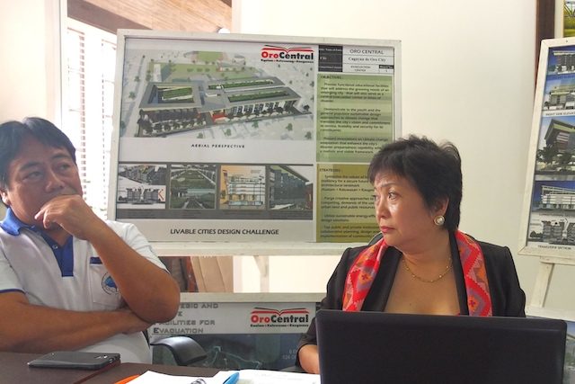
The city’s top urban planners, with the help of the United Architects of the Philippines, created the Planned City Expansion (PCE) in Barangay Lumbia, an expansive uptown village deemed suitable for expansion as it is not prone to flooding and has potential as the new city center.
Cagayan de Oro Mayor Oscar Moreno said the PCE was conceptualized under the United Nation Habitat’s Achieving Sustainable Urban Development (ASUD) project with the assistance of Arcadis, a global design, engineering, and management consulting company.
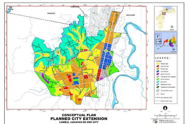
The PCE covers 820 hectares of land including the Lumbia airport which is now under the control of the Philippine Air Force’s 10th Tactical Operations Group, though the land is owned by the Department of Transportation and Communications (DOTC).
New growth area
Moreno said that the prime land, which is 180 meters above sea level, is a strategic area since future expansions under the Mindanao Logistics Infrastructure network (MLIN) pass through or near lumbia.
The MLIN is a long-term development plan for the road network in Mindanao. It includes new construction, and the upgrade and improvement of existing national roads and local roads.
All agencies, including the Department of Public Works and Highways, should use the MLIN plan as a guide for their own long and medium term development plans in the area covered by the plan.
The MLIN is intended to be used as a reference for agencies involved in the development of the Mindanao transport network.
A new national road is being constructed that will connect Iligan City to Bukidnon.
Engineer Isidro Borja, chief of the City Planning and Development Office, said that the PCE will be the new growth area of the city with its cluster of areas for development.
“It is like a self-contained community where everything is there, without having to go to other places to work or study,” Borja said.
Last year, Christopher Rollo, ASUD country program manager for UN Human Settlement, said that if the expansion of the city is left unplanned and unchecked, it is likely to be driven by real estate market that favors development for the rich.
“In Lumbia, it is where everything can be put in place like public spaces can remain public, road network connected to other districts without being blocked by private ownership of lands,” Rollo said.
Mixed-use modern district
Eileen San Juan, the city’s local economics and investment promotions chief said that she met with defense officials on January 11, 2016, to present the city’s PCE, which includes the Lumbia airport.
Moreno said the PCE was presented to President Benigno Aquino III and Cabinet officials as early as 2013 as part of the city government’s bid to promote the city.
San Juan said that the PCE is an exercise in urban planning which the city badly needed.
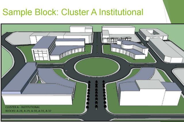
Under the PCE, there are 5 proposed clusters – Lumbia airport is under Prime Cluster A where local and national government offices are located.
“We will also replicate ‘Plaza Divisoria,’ which is a unique feature not found in any other city,” San Juan said.
Plaza Divisoria is a strip of 5 parks with statue of national hero Dr Jose Rizal, Andres Bonifacio, president Ramon Magsaysay, and mayor Justiniano Borja who first planned the city’s business district which Divisoria will be part of.
San Juan said the city wants a strategic and sustainable development node, a model for adaptive reuse, providing rural areas easy access to economic opportunities and social services.
“We want an institutional landmark with wide public parks and open space in harmony with medium to high density residential and commercial development which would showcase the city for livability and resilience,” San Juan said.
Borja said the PCE conforms with the approved Comprehensive Land Use Plan (CLUP).
“With the diverse housing market, low, medium, high end suitability for resettlement, this project will answer the housing shortage in the city,” Borja said.
Clusters
San Juan said each cluster under the PCE is designed according to use.
- Cluster A: Institutional and mixed use
- Cluster B: Farmstead/homestead villages
- Cluster C: Medium-density residential with community facilities, health and education, low intensity commercial area with at least 20% social housing with connection to town center and public spaces
- Cluster D: Residential villages in terraced fields, water retention ponds, soil erosion control and tourism activities with ecotourism (biking, trekking, adventure sports), mountain view resort with convention and meetings facilities
- Cluster E: Agri-processing Complex with waste management facility, mixed use Low–medium end housing, commercial, community facilities, value chain-considered efficient access to raw materials and markets
Borja said the PCE was designed considering road traffic. “All major roads will be 30 meters wide, while other roads will be at least 10 meters wide, both with provisions for pedestrian and cycling lanes.”
“We wanted the PCE is to be as walkable as possible; we want it to be environmentally and people friendly,” Borja added.
Adjustments
If EDCA enters into the picture and the airport is used by the US military, city officials said they would have to just adjust the design accordingly – but not without first exhausting efforts to convince the national government to favor the PCE.
Moreno said the long-term plan is for the common good.
“It is up to the national government if they’d allow the local government’s initial plan. We need them (national government) to cooperate because basically, the land belongs to to the Civil Aviation Authority and we cannot plan without them involved,” Moreno said.
Moreno added that the city government is taking steps to convince the national government on the expansion, as it is for the common good.
In its plan, residential areas will get 19.72% or 177.62 hectares; commercial area, 2.04% or 18.35 hectares; institutional 4.6% or 42.1 hectares; agro-industrial 2% or 17.87 hectares; mixed-used 15.8% or 142.9 hectares; commercial and transport facilities, 0.91% or 8.19 hectares; roads, 15.96% or 143.76 hectares; public spaces, 38.83% or 349.72 hectares.
“We will be expecting adjustments and needs to revisit the planning and resources needed to achieve our goal of the PCE,” San Juan said. – Rappler.com
Add a comment
How does this make you feel?
There are no comments yet. Add your comment to start the conversation.