SUMMARY
This is AI generated summarization, which may have errors. For context, always refer to the full article.
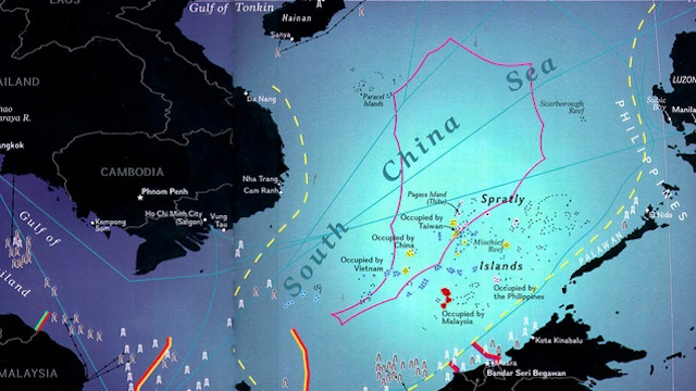
MANILA, Philippines – Chinese and Taiwanese scholars are preparing to study borderlines based on the so-called “Nine Dash” or “U-Shaped” demarcation line Beijing uses to claim virtually all of the South China Sea.
“We plan to give the international community a legal explanation of the U-shape line within one year, together with our advice and claims in response to international concerns,” said Wu Shicun, president of the National Institute for South China Sea Studies (NISCSS), state news agency Xinhua reported on Wednesday, October 24.
Wu added that the most important task for them to start the theoretical research on the U-shape line.”
The NISCSS report, compiled by ten Chinese and Taiwanese authors, called for “peaceful cooperation” between both sides but did not mention other claimants like Brunei, Malaysia, the Philippines or Vietnam.
The “Nine-Dash” line is used by China and Taiwan to claim a vast area of the South China Sea including the Paracel Islands (occupied by China but claimed by Vietnam) and the Spratly Islands, also disputed by Brunei, the Philippines, Malaysia and Vietnam.
According to the Chinese, this demarcation line — rejected by the other claimants — first appeared in 1948, before Mao Zedong’s Communist Party ousted Chiang Kai-shek’s Kuomintang from power and the People’s Republic of China was established. – Rappler.com
Add a comment
How does this make you feel?
There are no comments yet. Add your comment to start the conversation.