SUMMARY
This is AI generated summarization, which may have errors. For context, always refer to the full article.

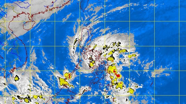
(2nd UPDATE) MANILA, Philippines – Tropical Depression Quinta, which weakened Wednesday, December 26, continued to move toward northern Palawan as it was bound to exit the Philippines the next day.
In its latest update issued at 5 pm, the Philippine Atmospheric, Geophysical, and Astronomical Services Administration (PAGASA) also raised Storm Warning Signal No. 1 over the following areas:
- Mindoro Provinces including Lubang Group of Islands
- Romblon
- Northern Palawan
- Calamian Group of Islands
- Cuyo Island
- Marinduque
- Aklan
- Capiz
- Antique
- Iloilo
- Guimaras
- Negros Occidental
PAGASA lowered Signal No. 1 in other areas, such as Cebu.
Quinta packs maximum sustained winds of 55 km/h near the center, and is forecast to move west at 24 km/h.
Due to Quinta, hundreds of passengers were stranded in various seaports in Eastern Visayas on Tuesday, December 25. Nearly 400 passengers were stranded in the ports of Hindang and Bato in Leyte, Liloan and San Ricardo in Southern Leyte, and Allen in Northern Samar, according to the Office of Civil Defense (OCD) in Eastern Visayas.
In Dap Dap Ferry Terminal in Allen, Northern Samar, at least 36 people were stranded, according to a regional police report. The report added that nearly 100 passengers were stranded in Abucay Terminal in Tacloban City.
The National Disaster Risk Reduction and Management Council (NDRRMC) put the total number of stranded passengers nationwide at almost 6,000. Most of the strandees are in Cebu and Manila.
Next area: Palawan
PAGASA expects Quinta to be at 460 km west of Coron, Palawan by Thursday afternoon, December 27, and outside the Philippine area of responsibility in the evening. By Friday afternoon, December 28, Quinta will likely be at 1,010 west of Coron, Palawan or over the South China Sea (West Philippine Sea).
The estimated rainfall amount within the 350 km diameter of the storm is 5-15 mm/h (heavy-intense).
PAGASA advised residents living in low-lying and mountainous areas under storm signals No. 2 and No. 1 to watch out for possible flash floods and landslides.
Those living in coastal areas under storm signal No. 2 should brace for big waves or storm surges generated by Quinta.
Fishing boats and other small vessels should not venture into the seaboards of Luzon and over the eastern seaboards of Visayas and Mindanao due to the combined effects of Quinta and the northeast monsoon or hanging amihan. – Rappler.com
Add a comment
How does this make you feel?
There are no comments yet. Add your comment to start the conversation.