SUMMARY
This is AI generated summarization, which may have errors. For context, always refer to the full article.

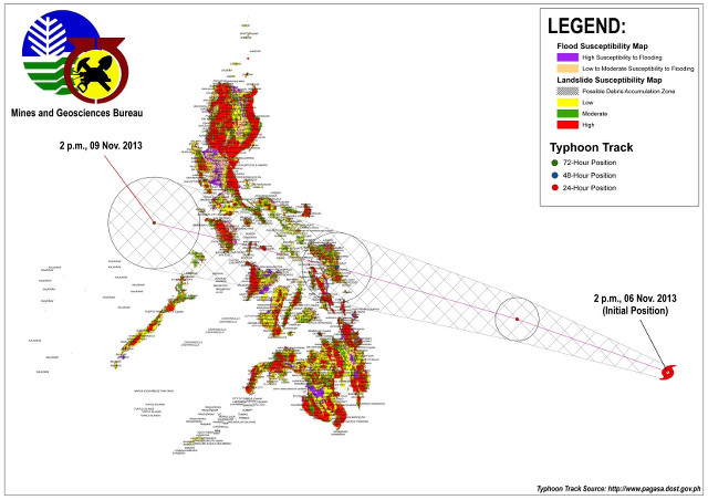
MANILA, Philippines – Villages along the path of Typhoon Yolanda (international codename Haiyan) are highly susceptible to landslides, according to data released by the Mines and Geosciences Bureau (MGB) on Friday, November 8.
These 41 barangays in Region IV-B or MIMAROPA, the region where Yolanda is headed according to state weather bureau PAGASA’s forecast, have either “high to very high” or “very high” vulnerability to landslides.
The Category 5 super typhoon, the strongest to hit the country in 2013, will make its way to Busuanga, Palawan, southern part of Mindoro, and other parts of MIMAROPA before exiting the Philippine Area of Responsibility on the morning of Saturday, November 9.
The threatened barangays – spread out across Marinduque, Occidental Mindoro, Oriental Mindoro, and Palawan may suffer even more loss of lives and property due to their susceptibility to landslides.
The barangays are the following:
Marinduque (15)
Tiguion, Bantay, Mainit, Duyay, Puyog, Tugos, Binunga, Canat, Hinapulan, Malibago, Bonliw, Dampulan, Nangka, Yook, Pulog-Parang
Oriental Mindoro (10)
Balatero, San Isidro, Sinandigan, Sabang, Villaflor, San Vicente, Ilag, Poblacion, Calangatan, San Agustin
Occidental Mindoro (10)
San Agustin, Balikyas, Balao, Taguilos, Cambijang, Mabini, Cawayan, Concepcion Sur, Manhac, Poblacion
Palawan (6)
Poblacion, Old Guinlo, Binduyan, Napsan, Cabayugan, Tagabinit
Below is the complete list of landslide-prone barangays in 5 other regions – Bicol, Western Visayas, Central Visayas, Eastern Visayas, and Caraga – as assesed by the Mines and Geosciences Bureau:
List of barangays likely to be affected by Rappler Philippines
Previous data from MGB also showed that Caraga region in Mindanao is the area most susceptible to typhoon-related disasters with 85% of its cities and municipalities highly prone to flooding and 62% highly vulnerable to landslides.
Meanwhile, 68 localities all over the Philippines have experienced or can expect storm surges – rise in sea level due to strong winds – before Yolanda exists the Philippines. – Rappler.com
Add a comment
How does this make you feel?
There are no comments yet. Add your comment to start the conversation.