SUMMARY
This is AI generated summarization, which may have errors. For context, always refer to the full article.

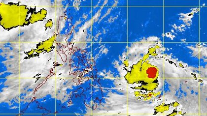
MANILA, Philippines – Tropical storm “Butchoy” (international codename Guchol) has been upgraded into a Severe Tropical Storm on Thursday afternoon, June 14. It has entered the Philippine Area of Responsibility.
The state weather bureau PAGASA said “Butchoy” was last spotted at 780 kilometers east of Guiuan, Eastern Samar, moving west northwest at 20 km per hour.
“Butchoy” is packing maximum sustained winds of 95 kph near the center, with gusts of up to 120 kph.
By Friday morning, the storm is expected to be 560 km east of Virac Catanduanes; by Satuday morning, it will be 320 km northeast of the town. It will then move to around 310 km northeast of Aparri, Cagayan, by Sunday morning.
Rainfall is estimated to be 15-25 millimeters per hour, considered heavy, within the 300 km diameter of the storm, PAGASA said.
No public storm warning signals have been raised so far.
Bicol and Eastern Visayas will also feel the effects of the enhanced monsoon by Friday. Fishermen and seafarers in these areas are also warned of rough seas.
Earlier, the US National Oceanic and Atmospheric Administration (NOAA) forecast Butchoy to slow down and gradually intensify, and could become a typhoon within the next 24 hours.
Forecast models by the NOAA, the Joint Typhoon Warning Center, and the Japan Meteorological Agency show the storm narrowly grazing northern Luzon, or missing it altogether.
PAGASA, meanwhile, also forecasts the storm to miss land, but is not discounting the possibility of the storm crossing the Visayas, but said the path will curve west northwest in the next 24-48 hours.

Warnings
Benito Ramos, head of the National Disaster Risk Reduction Management Council (NDRRMC), earlier warned local governments in the eastern seaboard of the country, specifically those in Bicol, Eastern Visayas, CARAGA, SOCCSKSARGEN, and Southern Mindanao regions, to prepare for flooding, heavy rains, and landslides.
Ramos said local government units have already activated and convened their local disaster councils to review contingency plans in preparation for Butchoy. Evacuation centers, medicines, and other supplies have also been prepared, he said.
The weather bureau is also closely monitoring water levels of major dams, especially in Luzon, as rain continued to fall over the area.
Forecast
Meanwhile, the southwest monsoon is still affecting much of Luzon, bringing rainshowers and thunderstorms.
Most of Luzon, specifically the western side of the region, will experience occasional rains, PAGASA said, while the rest of the country will be partly cloudy to cloudy with isolated rains & thunderstorms.
Due to Butchoy and the southwest monsoon, small seacraft are advised not to go out to sea, due to rough seas in Luzon, Visayas, and northeastern Mindanao. – Rappler.com
Click on the links below for related stories on ‘Butchoy’:
Add a comment
How does this make you feel?
There are no comments yet. Add your comment to start the conversation.