SUMMARY
This is AI generated summarization, which may have errors. For context, always refer to the full article.

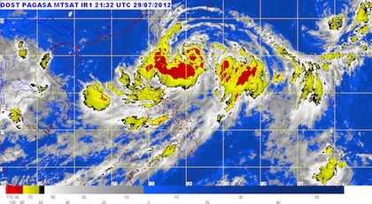
MANILA, Philippines (UPDATED) – Tropical storm Gener (international codename Saola) has slowed down slightly as it continued to move towards the northwest on Monday, July 30, bringing rain over large areas of the country.
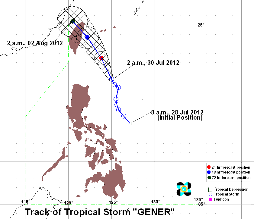
Weather bureau Pagasa, in its 11 am bulletin, reported Gener to be 360 kilometers (km) east northeast of Aparri, Cagayan, or 290 km east southeast of Basco, Batanes, with maximum sustained winds of 105 km per hour (km/h) near the center and gusts of up to 135 km/h.
The storm is moving in a north northwest direction at a slow pace, 11 km/h.
Public storm warning signal number 2 has been hoisted over Cagayan, including the Calayan and Babuyan islands, and Batanes. These areas will experience winds between 61-100 km km/h.
Meanwhile, signal number 1 has been raised over Isabela, Kalinga, and Apayao. Here, winds will be between 45-60 km/h.
Within the 700 km radius of the tropical storm, rainfall is heavy to intense, at around 10-20 millimeters per hour (mm/h), according to the weather bureau.
It is forecast to be 210 km east northeast of Basco by Tuesday (July 31) morning, and 340 km north northeast of the town by Wednesday.
It is expected to be out of the Philippine Area of Responsibility by Thursday, and will be affecting Taiwan.

The storm will continue to enhance the Southwest Monsoon, bringing rain over Central and Southern Luzon, most of the Visayas (western sections in particular), and Northern Mindanao.
The bureau has also issued strong to gale force wind warning over the seaboards of Northern, Central, and Southern Luzon, Visayas, and the eastern seaboard of Mindanao.
Meanwhile, the bureau made no mention of the shallow low pressure area affecting parts of the National Capital Region and Central Luzon in the 5 am bulletin.
The last update on the SLPA was issued at 12:56 am on Monday. It was last spotted in the vicinity of Rizal, which caused moderate to strong rain with strong winds over Bataan, Bulacan, Pampanga, Metro Manila, and nearby areas.
Forecast
The rest of Luzon and Visayas, meanwhile, will have cloudy skies with scattered to widespread rains and thunderstorms. Mindanao will be partly cloudy to cloudy with isolated rain and thunderstorms.
Moderate to strong winds will be coming from the southwest over Southern Luzon, Visayas, and Mindanao. The rest of Luzon will experience winds coming from the northeast to northwest.
Coastal waters will be moderate to rough, the bureau added.
The bureau is continually warning residents near low lying and mountainous areas in places with storm warning signals, as well as those affected by the monsoon, to be prepared against possible landslides and flashfloods.
Coastal communities in these areas area also alerted against big waves and storm surges.
In addition, the effects of the monsoon and the tropical storm will bring rough seas, and small seacraft are advised not to venture to sea.
The next bulletin on Gener will be out by 5 pm Monday.
Dams release water
The National Disaster Risk Reduction and Management Council (NDRRMC), in its latest situation report Monday, said excess water from both the La Mesa and Ipo dams will continue to affect low-lying areas downstream.
Excess water from the La Mesa Dam will affect areas along the Tullahan River, Fairview, Novaliches, and the CAMANAVA area. Alert for all possible increases in water level downstream from the dam is still up.
Meanwhile, Ipo Dam has released water from its reservoir since 1:50 am Monday, after water levels breached the 100.80-meter critical level.
It reached 100.82 m at 1:50 am, prompting the dam management to open Gate B by 30 centimeters and discharging 47.9 cubic meters of water.
The dam management continued to open the gates of the dam until 5 am.
Low-lying areas along the Angat River from Norzagaray to Hagonoy in Bulacan are affected by the releases.
Bustos Dam also opened 2 gates to release excess water from its reservoir since 5 am.
Thousands affected
The NDRRMC reported 13,470 people across 3 regions in Luzon and Visayas have been affected by the tropical storm, with 12,933 of them being assisted by the agency.
The storm has claimed the life of Ronald Necor, 33 years old, who died last Saturday, July 28, when he drowned at Pangalcagan, Bugasong, Antique.
Five roads and 7 bridges were damaged in the provinces of Benguet, Mountain Province, Ifugao, Palawan, and Occidental Mindoro.
Power failure was also reported in parts of Catanduanes, Negros Oriental, Batangas, Rizal, and Quezon City.
Due to inclement weather, numerous local government units and schools have suspended classes at various levels on Monday. – Rappler.com
Add a comment
How does this make you feel?
There are no comments yet. Add your comment to start the conversation.