SUMMARY
This is AI generated summarization, which may have errors. For context, always refer to the full article.
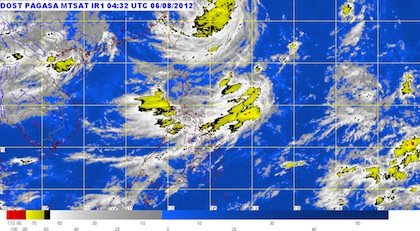
MANILA, Philippines – After ten days of almost continuous rainfall, a new storm may be developing east of Luzon, weather bureau Pagasa said on Monday, August 6.
In its 11am bulletin, Pagasa noted that a shallow low pressure area (SLPA) has been spotted 920km east of northern Luzon.
SLPAs have a 40% chance of developing into a tropical storm depending on its distance to land and the oceanic temperatures, especially if the average temperature is around 27 degrees Celsius.
Pagasa also predicted moderate to heavy rains over the next few days in western Luzon — Pangasinan, Zambales, Batangas, and Mindoro and Panay islands as well as Metro Manila — due to the southwest monsoon or Hagabat.
Light to moderate rains will continue to be experienced over the rest of Luzon, the weather bureau added.
Classes suspended, rivers and dams may overflow
Flooding caused by heavy rainfall since Sunday evening prompted authorities to suspend classes in various areas of the National Capital Region, including Mandaluyong, Marikina, Pasay, Quezon City and Valenzuela. (Read: Classes cancelled on August 6 due to rains, floods)
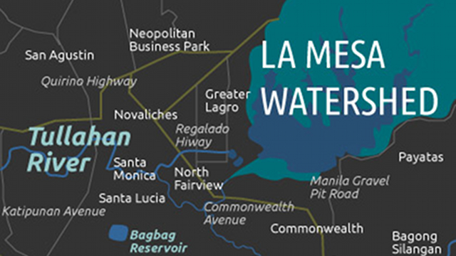
Marikina and Quezon City and particular are preparing for floods triggered by the overflowing of the Marikina River and the La Mesa Dam.
At least four barangays in Marikina may have to be evacuated if the level of the river continues to rise above 17m and reaches alarm level 4 or compulsory evacuation status.
La Mesa reached its spilling level at 2am on Monday morning. (Read: La Mesa dam overflows)
The dam is designed to overflow to one area, focused on the Tullahan River, so the affected areas will be parts of Fairview, Valenzuela, Navotas, Quezon City and Malabon.
Yellow warning signal for Metro Manila
At 2pm on Monday, Pagasa lowered its floods warning signal to “yellow” from “green”, in place since 10pm on Sunday.
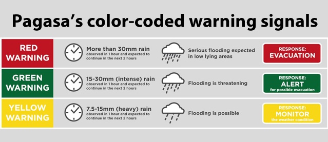
The yellow warning signifies that flooding is possible low-lying areas and those located near the river channels, where residents should monitor the weather for possible evacuation.
Pagasa will issue its next update at 5pm. – Rappler.com
Add a comment
How does this make you feel?
There are no comments yet. Add your comment to start the conversation.