SUMMARY
This is AI generated summarization, which may have errors. For context, always refer to the full article.

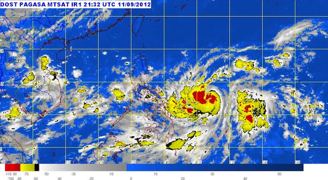
MANILA, Philippines (UPDATED) – Tropical storm ‘Karen’ (international codename Sanba) and a low pressure area continue to hover within the Philippine Area of Responsibility, while rain and clouds are in Wednesday’s forecast for most of the country.
The tropical storm has intensified slightly on Wednesday morning, September 12, as it continues to move to the northwest, state weather bureau PAGASA said in its 11 am bulletin.
Karen was last located 620 km east of Borongan, Eastern Samar (12.8°N, 131.6°E), with maximum sustained winds of 85 km/h near the center and gusts of up to 100 km/h.
The weather disturbance is forecast to move north northwest at a speed of 15 km/h.
The PAGASA forecast track showed that it is not likely to move near land; instead it will continue to move over the East Philippine Sea.
By Thursday morning it is estimated to be 770 km east of Infanta, Quezon. It will mve to 620 km east of Tuguegarao City by Friday morning.
No public storm warning signal has been raised.
Moderate to heavy rainfall (10-20 mm/h) is estimated within the 550 km diameter of the tropical storm.
Meanwhile, the low pressure area spotted in the West Philippine Sea was last located 250 km west of Zambales (15.4°N, 117.3°E).
Wednesday’s weather
On Wednesday, Metro Manila will be partly cloudy to cloudy, with light to moderate rain and thunderstorms, accompanied by light to moderate winds from the southwest.
Eastern Visayas, Zamboanga, and Caraga regions, meanwhile, will have occasional moderate to heavy rain, the bureau said. These could trigger landslides and flashfloods, PAGASA warned.
The rest of the archipelago will have scattered light to moderate rain, the bureau added.
Strong to gale force winds are expected in the eastern seaboards of Visayas and Mindanao, accompanied by rough to very rough seas, the bureau added. Small seacraft are advised to stay out of the water.
PAGASA 24-Hour Public Weather Forecast, 12 September 2012, 5am
– Rappler.com
Add a comment
How does this make you feel?
There are no comments yet. Add your comment to start the conversation.