SUMMARY
This is AI generated summarization, which may have errors. For context, always refer to the full article.

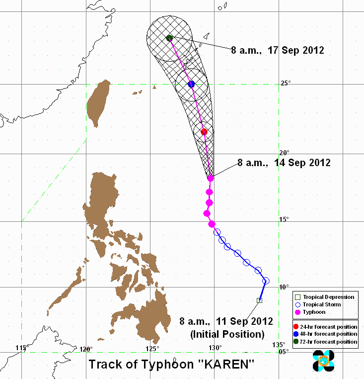
MANILA, Philippines – Typhoon Karen (international codename Sanba) continues to cross the Philippine Sea on Friday, September 14, as Okinawa and neighboring islands prepare for its arrival.
As of 10 am, Karen was located 740 kilometers east of Aparri, Cagayan (18.5°N, 129.6°E), carrying maximum sustained winds of 185 km/h near the center and gusts of up to 220 km/h.
It is moving 15 km/h towards the north-northwest, state weather bureau PAGASA said, or the general direction of Okinawa, Japan.
It is expected to be 770 km east of southern Taiwan by Saturday morning, and will reach Okinawa by Sunday or Monday.
Heavy to intense rainfall (15-30 mm/h) is expected with the 550 km diameter of the typhoon.
Forecast tracks from the US Navy’s Joint Typhoon Warning Center (JTWC), Taiwan Central Weather Bureau, and the Japan Meteorological Agency show it eventually moving towards the general direction of the Korean peninsula. The JTWC has categorized Karen/Sanba as a supertyphoon.


Data from the NASA Aqua satellite showed that the eye of Karen/Sanba to be 20 nautical miles (23 miles/37 km) wide, “surrounded by a thick area of strong convection (rising air that forms the thunderstorms that make up the storm) and strong thunderstorms.”
NASA has labeled the typhoon as an “annular typhoon,” characterized by its symmetric shape and stable, strong structure.
 about 20 nautical miles wide, surrounded by a thick area of strong thunderstorms (purple) with very cold cloud temperatures. Credit: NASA/JPL, Ed Olsen")
It will pass close to the Kadena Air Base in Okinawa, based on forecasts.
The typhoon is not directly affecting the Philippines, but it will continue to enhance the southwest monsoon. No public storm warning signal is in effect in any part of the country.
The monsoon will continue to bring light to moderate rain over parts of Luzon and Visayas, particularly over Metro Manila, Southern Luzon, and Western Visayas.
Karen’s strong winds will also affect the coastal waters along the country’s east coast, which could be dangerous to small seacraft. – Rappler.com
Add a comment
How does this make you feel?
There are no comments yet. Add your comment to start the conversation.