SUMMARY
This is AI generated summarization, which may have errors. For context, always refer to the full article.

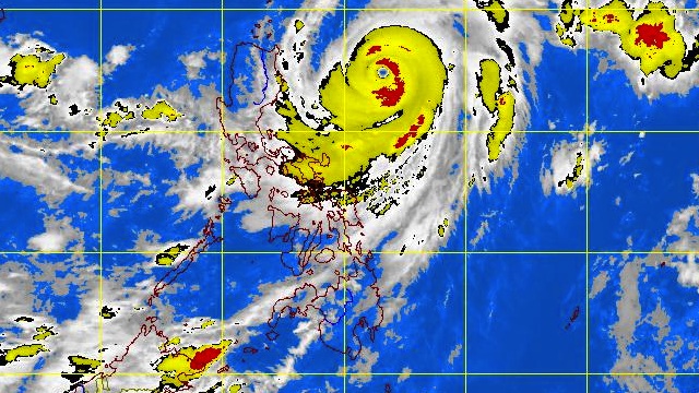
MANILA, Philippines – More public storm signal warnings were raised as typhoon “Lawin” continued its path toward northern Luzon and Batanes, weather bureau PAGASA said on Wednesday, September 26.
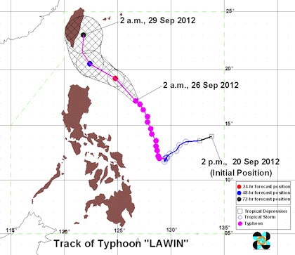
In its 5 am bulletin, PAGASA noted that as of 4 am Lawin (international codename: Jelawat) was located 465 km East of Tuguegarao (17.3°N, 126.6°E) with maximum sustained winds of 205 km/h near the center and gusts of up to 240 km/h.
The typhoon is forecast to move Northwest at 11 km/h and will be 325 km East of Calayan Island on Thursday morning.
Storm signal warnings
Public storm signal warnings #2 (61-100 km/h winds) were hoisted over 4 provinces:
- Batanes Group of Islands
- Cagayan
- Calayan
- Babuyan
Meanwhile, public storm signal warnings #1 (30-60 km/h winds) are in place for another 4 provinces:
- Ilocos Norte
- Kalinga
- Apayao
- Abra
- Isabela
The weather bureau alerted residents living in low lying and mountainous areas under public storm warning signal #2 and #1 against possible flashfloods and landslides.
Likewise, those living in coastal areas under public storm warning signal #2 could experience against big waves or storm surges generated by the typhoon, PAGASA added.
The estimated amount of rain is 10-20 mm per hour (heavy-intense) within the 850 km diameter of Lawin.

Weather forecast for Wednesday
The typhoon will experience storms and very rough seas to Cagayan, Calayan, Babuyan and Batanes, while Ilocos Norte, Kalinga, Abra, Apayao and Isabela will suffer heavy rain and gusty winds.
Cloudy skies with occasional moderate to heavy rains which may trigger flashfloods and landslides are expected in Bicol and Visayas.
Metro Manila, Calabarzon, Mindanao and the rest of Luzon will have occasional light to moderate rains and thunderstorms.
Moderate to strong Northeast-Northwest will prevail over Central Luzon, Nueva Vizcaya and Quirino, while the wind over southern Luzon, Visayas and Mindanao will be coming from the Southwest.
The coastal waters throughout the archipelago will be moderate to rough.
Here is PAGASA’s latest 24-hour public weather forecast:
– Rappler.com
Add a comment
How does this make you feel?
There are no comments yet. Add your comment to start the conversation.