SUMMARY
This is AI generated summarization, which may have errors. For context, always refer to the full article.
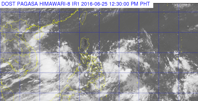
MANILA, Philippines – State weather bureau PAGASA said there is a small possibility for now that one of the two low pressure areas (LPAs) in the Philippine Area of Responsibility will develop into a tropical depression.
“Sa ngayon, maliit ang possibility na mag-develop into a tropical depression (As of now, there is a small possibility that it will develop into a tropical depression),” PAGASA weather forecaster Jun Galang told Rappler in a phone interview past noon on Saturday, June 25.
Galang was referring to the LPA located 850 km east of Surigao City, Surigao del Norte as of 10 am Saturday.
“Napunta [‘yung LPA] sa area na malakas ang vertical wind shear. Ito ay [malakas na] hangin sa upper level ng atmosphere natin (The LPA is in an area where there is strong vertical wind shear. This is a strong wind located at the upper level of our atmosphere),” he added.
Historically, large values of wind shear are connected with reduced tropical storm activity and intensification, according to the Geophysical Fluid Dynamics Laboratory of the US’ National Oceanic and Atmospheric Administration.
Galang added: “Pero sa nakikita natin, active yung Pacific kaya di natin maiaalis na maaaring mabuo (But from what we’re seeing, the Pacific is active, so we cannot rule out that it might develop into a tropical depression).”
The LPA will be locally named “Ambo” once it develops into a tropical depression.
The other LPA was spotted 160 km southeast of Hinatuan, Surigao del Sur. Galang said this LPA, which will hit land soon, is expected to dissipate.
Both LPAs are embedded along the intertropical convergence zone, which will bring light to moderate rains and thunderstorms over Southern Luzon, Visayas, and Mindanao beginning Saturday up to 1-2 days, according to Galang.
The next bulletin on the two LPAs will be issued at 5 pm Saturday. – Jee Y. Geronimo/Rappler.com
Add a comment
How does this make you feel?
There are no comments yet. Add your comment to start the conversation.