SUMMARY
This is AI generated summarization, which may have errors. For context, always refer to the full article.

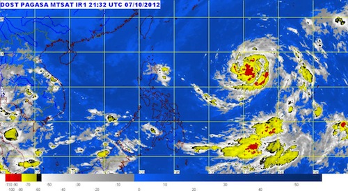
MANILA, Philippines (UPDATED) – Tropical storm Prapiroon has entered the Philippine Area of Responsibility (PAR) late Monday morning, and has been named “Nina.”
Tropical storm Nina was located 1,260 kilometers east of Cagayan (18.0°N, 135.0°E) as of 10 am, state weather bureau PAGASA said in its severe weather bulletin issued at 11 am.
Nina has maximum winds of 75 km/h near the center, and gusts of up to 90 km/h. The storm is moving west at 9 km/h.
The storm won’t affect any part of the country yet. It is forecast to move 1,070 east of Cagayan by Tuesday morning, and 850 km east of Aparri by Wednesday.
Moderate to heavy rainfall (5-10 mm/h) is estimated to fall within the 500 km diameter of the tropical storm.
On the other hand, a low pressure area has been spotted 340 km east of Infanta, Quezon (15.0°N, 125.2°E), bringing occasional light to moderate rain over most of the eastern seaboard of Luzon.
Meanwhile, Palawan and Mindanao will have occasion light to moderate rain or thunderstorms, due to an Intertropical Convergence Zone (ITCZ) in the area.
The rest of the archipelago, meanwhile, will have partly cloudy skies with brief rain or thunderstorms.
Here is the 24-hour public weather forecast for Monday, October 8, issued at 5 am.
PAGASA 24-Hour Public Weather Forecast, 8 October 2012, 5am
– Rappler.com
Add a comment
How does this make you feel?
There are no comments yet. Add your comment to start the conversation.