SUMMARY
This is AI generated summarization, which may have errors. For context, always refer to the full article.
What’s the weather like in your area? Report the situation through Rappler’s Agos or tweet us at @rapplerdotcom.
For the latest updates on Typhoon Lawin (Haima), go to our live blog
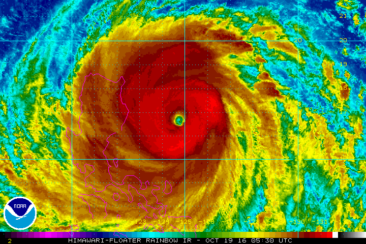
MANILA, Philippines – Typhoon Lawin (Haima) intensified into a super typhoon early Wednesday afternoon, October 19, posing a serious threat to the provinces of Cagayan and Isabela.
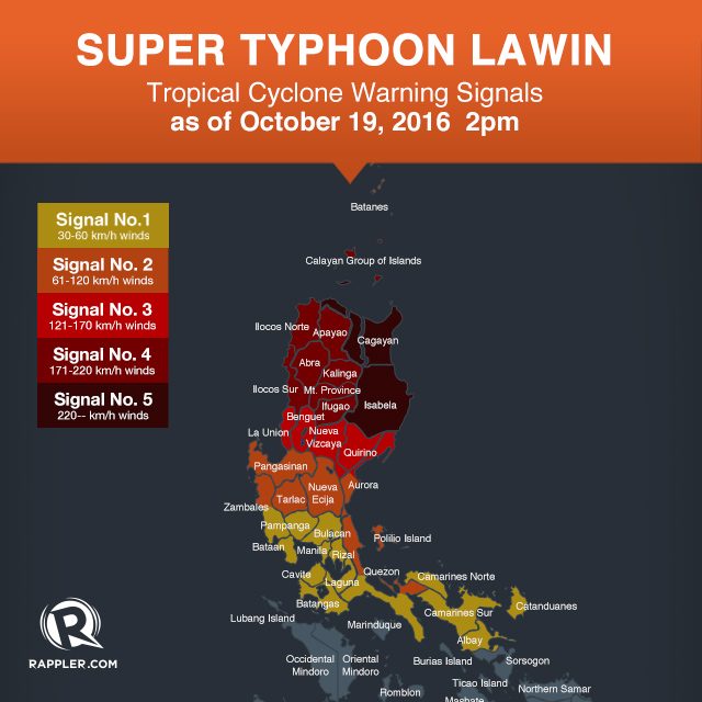
The two provinces are now under signal number 5 – the highest tropical cyclone warning signal.
In its bulletin issued 2 pm on Wednesday, state weather bureau PAGASA said Lawin now has maximum winds of up to 225 kilometers per hour (km/h) and gustiness of up to 315 km/h.
Given its massive strength, Lawin is threatening to bring destructive floods and landslides. Moderate to heavy rain is expected within its 800-km diameter.
So far, Lawin is now 300 kilometers east of Casiguran, Aurora, moving west northwest at a slightly slower 24 km/h from the previous 26 km/h.
Below is the complete list of areas under warning signals.
Signal number 5:
- Cagayan
- Isabela
Signal number 4:
- Apayao
- Kalinga
- Ilocos Norte
- Ilocos Sur
- Abra
- Mt Province
- Ifugao
- Calayan Group of Islands
Signal number 3:
- La Union
- Benguet
- Nueva Vizcaya
- Quirino
- northern Aurora
Signal number 2:
- Batanes
- Pangasinan
- rest of Aurora
- Tarlac
- Nueva Ecija
- northern Zambales
- northern Quezon including Polillo Island
Signal number 1:
- rest of Zambales
- Bulacan
- Bataan
- Pampanga
- Rizal
- rest of Quezon
- Cavite
- Laguna
- Batangas
- Metro Manila
- Camarines Norte
- Camarines Sur
- Catanduanes
- Albay
PAGASA earlier said powerful winds experienced in areas under signal number 4 or 5 “can destroy high- to low-risk structures” as well as topple trees and transmission towers.
Storm surges up to 5 meters high are also possible.
Sea travel is risky in the eastern seaboard of Southern Luzon and the northern and eastern seaboards of Samar.
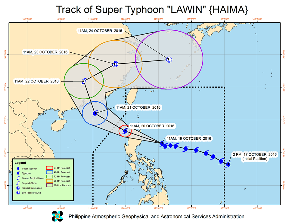
Lawin is expected to make landfall in the Cagayan-Isabela area between 11 pm on Wednesday and 2 am on Thursday, October 20. PAGASA warned it will be “destructive.”
After making landfall, Lawin will cross Ilocos Norte and Apayao.
It is expected to leave the Philippine Area of Responsibility (PAR) either on Thursday night or early Friday, October 21.
– Rappler.com
Add a comment
How does this make you feel?
![[In This Economy] Can the PH become an upper-middle income country within this lifetime?](https://www.rappler.com/tachyon/2024/04/tl-ph-upper-income-country-04052024.jpg?resize=257%2C257&crop=295px%2C0px%2C720px%2C720px)


![[OPINION] Controversy over ASEAN’s ‘Swift’ week](https://www.rappler.com/tachyon/2024/03/tl-asean-swift-week.jpg?resize=257%2C257&crop=357px%2C0px%2C720px%2C720px)

There are no comments yet. Add your comment to start the conversation.