SUMMARY
This is AI generated summarization, which may have errors. For context, always refer to the full article.

FOR LIVE UPDATES, stay with Rappler’s Bopha/Pablo live blog here.
MANILA, Philippines (UPDATED) – More areas in Visayas and Mindanao are under public storm warning signals Monday, December 3, as typhoon Pablo (international codename Bopha) moves closer to land.
The typhoon has weakened slightly, according to state weather bureau PAGASA.
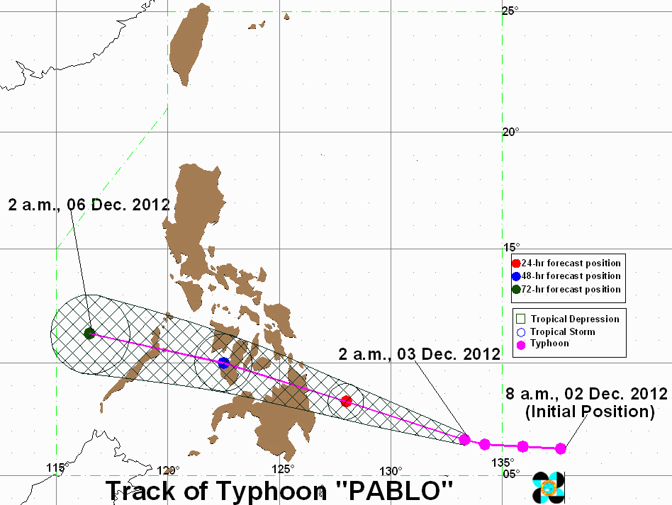
Based on PAGASA’s update at around 9 am, Pablo was last spotted 590 km southeast of Hinatuan, Surigao del Sur (6.9°N 131.8°E), carrying maximum sustained winds of 175 km/h near the center and gusts of up to 210 km/h.
Public storm warning signal #2 (61-100 km/h winds in the next 24 hours) has been raised over Surigao del Sur and the northern part of Davao Oriental, while the following provinces are under signal number 1 (30-60 km/h winds in the next 36 hours):
- Surigao del Norte
- Siargao Island
- Dinagat Island
- Agusan del Norte
- Agusan del Sur
- Rest of Davao Oriental
- Davao del Norte including Samal Island
- Compostela Valley
- Bukidnon
- Misamis Occidental
- Misamis Oriental
- Camiguin
- Lanao del Norte
- Lanao del Sur
- Siquijor
- Bohol
- Biliran
- Camotes Island
- Southern Leyte
- Leyte
- Eastern Samar
- Western Samar
Within the typhoon’s 600 km diameter, heavy to intense rainfall is expected (20-30 mm/h).
The weather system is moving west northwest at 24 km/h, and is estimated to be 175 km east of Hinatuan by Tuesday morning, Deceber 4. It will be 80 km south of lloilo City by Wednesday, and will be 280 km northwest of Puerto Princesa City by Thursday.
“Residents living in low lying and mountainous areas under public storm warning signal #2 and #1 are alerted against possible flashfloods and landslides,” the bureau warned.
Coastal areas are advised to be on the lookout for storm surges and big waves, and small seacraft are advised to stay onshore, especially along the eastern seaboards of Visayas and Mindanao.
Monday weather
Stormy weather can be expected in Surigao del Sur and the northern part of Davao Oriental, accompanied by rough seas.
Eastern Visayas, Caraga, and parts of northern and southern Mindanao and central Visayas, as well as the Bicol Region, can expect rainy weather with gusty winds, accompanied by moderate to rough seas.
Northern Luzon, meanwhile, will have cloudy skies and light rain, while the rest of the country will have partly cloudy skies with brief rain and thunderstorms.
Prevailing winds will come from the northeast to north over the rest of the country.
Strongest storm of 2012
Pablo is the 16th and probably the last typhoon to affect the Philippines in 2012, but it may also be the strongest to hit the country this year.
“This is a powerful storm, perhaps the strongest this year, and we enjoin everyone to take precautionary measures,” Ramos told AFP.
The NDRRMC chief said local governments in the areas likely to be soaked by heavy rains had been advised to undertake precautionary evacuations if needed, though none has been ordered so far.
Nearly 100 people died and more than a million were displaced in August by the Habagat floods in Metro Manila and other parts of Luzon.
A total of 19 typhoons struck the Philippines last year, leading to more than 1,500 deaths and affecting nearly 10 percent of the total population, according to the government.
The worst calamity was tropical storm “Sendong” in December 2011. – Rappler.com, with reports from Agence France-Presse
Add a comment
How does this make you feel?
There are no comments yet. Add your comment to start the conversation.