SUMMARY
This is AI generated summarization, which may have errors. For context, always refer to the full article.

MANILA, Philippines (UPDATED) – The state weather bureau on Monday morning, December 3, raised Storm Warning Signal No. 3 over 7 areas, including Surigao del Sur, over which Typhoon Pablo is expected to make landfall.
The Philippine Atmospheric, Geophysical, and Astronomical Services Administration (PAGASA) raised Signal No. 3 over 7 areas. This means winds of 101 to 185 km/h will batter the following:
-
Surigao del Sur
-
Surigao del Norte
-
Siargao
-
Dinagat
-
Agusan del Norte
-
Agusan del Sur
-
Davao Oriental
Signal No. 2, which indicates 61 to 100 km/h winds, is meanwhile hoisted over the following:
-
Southern Leyte and Bohol
-
Camiguin
-
Misamis Oriental
-
Bukidnon
-
Davao del Norte
-
Compostela Valley
The state weather bureau also raised Signal No. 1 over the following areas, which will likely experience 30 to 60 km/h winds due to Pablo:
-
Cuyo Island
-
Eastern Samar
-
Western Samar
-
Leyte
-
Biliran
-
Aklan
-
Capiz
-
Antique
-
Iloilo
-
Guimaras
-
Negros Occidental
-
Negros Oriental
-
Cebu
-
Siquijor
-
Zamboanga del Norte
-
Zamboanga del Sur
-
Zamboanga Sibugay
-
Lanao del Norte
-
Lanao del Sur
-
Davao del Sur
-
North Cotabato
-
Maguindanao
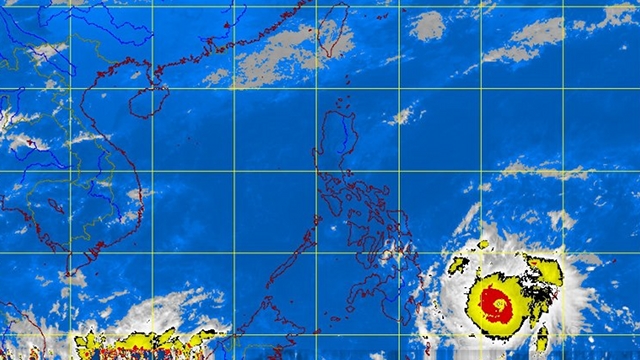
In its 11 am update, PAGASA said Pablo maintained its strength with maximum sustained winds of 175 km/h and gusts of up to 210 km/h. It was located 510 km southeast of Hinatuan, Surigao del Sur. (Read PAGASA’s full report below.)
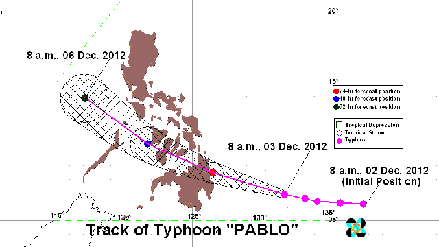
PAGASA expects Pablo to make landfall over Surigao del Sur by Tuesday morning, December 4.
The state weather bureau sees Pablo at 30 km east of Hinatuan, Surigao del Sur by Tuesday morning. By Wednesday morning, it is expected to be at 150 km west of Iloilo, and by Thursday, at 400 km west of Calapan, Oriental Mindoro.

Estimated rainfall is between 15 to 30 mm/h – heavy to intense levels – within the typhoon’s 600 km diamater.
PAGASA said Pablo is the 16th and likely the last typhoon to hit the Philippines this year. But it could also be the strongest, surpassing Tropical Storm Sendong, which killed over 1,470 people, injured over 2,000, and affected over a million in 2011.
On Saturday, December 1, National Disaster Risk Reduction and Management Council executive director Benito Ramos told Rappler that one advantage, this time around, is the longer time to prepare for the typhoon. He said PAGASA has warned the public about Pablo since Tuesday last week.
The Department of the Interior and Local Government, for its part, has activated disaster monitoring systems in Bicol, Central Visayas, Eastern Visayas, Northern Mindanao, and Caraga in preparation for Pablo. – Rappler.com
Add a comment
How does this make you feel?
There are no comments yet. Add your comment to start the conversation.