SUMMARY
This is AI generated summarization, which may have errors. For context, always refer to the full article.
What’s the weather like in your area? Report the situation through Rappler’s Agos or tweet us at @rapplerdotcom.
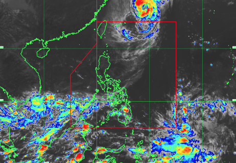
MANILA, Philippines – An intertropical convergence zone (ITCZ) is expected to bring light to moderate with occasional heavy rain over Mindanao and Palawan on Sunday, October 29.
The ITCZ affects Zamboanga peninsula, northern Mindanao, Caraga region and Palawan, according to the bulletin issued by state weather bureau PAGASA at 4pm on Saturday, October 28.
Aside from the ITCZ, a northeasterly surface windflow is affecting the Cordillera and Cagayan Valley in northern Luzon. The said areas will experience partly cloudy to cloudy skies with isolated light rain on Sunday.
Localized thunderstorms, on the other hand, are affecting Metro Manila and the rest of the country. Expect partly cloudy to cloudy skies with possible isolated rain showers or thunderstorms, said PAGASA.
As of Saturday afternoon, the severe tropical storm Quedan (Saola) was already 995 kilometers northeast of Basco, Batanes outside the Philippine Area of Responsibility (PAR).
Quedan did not make landfall in the Philippines, though its outer rainbands earlier brought some rain. (READ: FAST FACTS: Tropical cyclones, rainfall advisories) – Rappler.com
Add a comment
How does this make you feel?
There are no comments yet. Add your comment to start the conversation.